I am about to buy a slightly used XT (my 660 is giving notice that it's old and tired) and I would be grateful for any suggested topics to look at here. I have read every word of jfheath's excellent sticky post and am inclined to try using tracks alone to avoid recalc issues.I often shut off the voice directions anyway.
But I'm open to suggestions and eager to learn more. I know my way around Basecamp (Mac) and have successfully planned and ridden numerous 3000-mile trips using it and my 660, so I'm familiar with needing to know a unit's quirks to avoid confusion, but there will no doubt be a whole new set to discover on the XT.
Thanks in advance,
-dan
Suggested reading, please
-
danham
- Posts: 412
- Joined: Fri Jul 13, 2018 2:25 pm
- Location: Cape Cod, MA
- Has liked: 148 times
- Been liked: 139 times

Suggested reading, please
Last edited by danham on Wed Feb 01, 2023 10:39 pm, edited 1 time in total.
Zumo XT, 660, nuvi 760 and many retired units dating back to the GPS III+
2018 Kawasaki Ninja H2 SX SE
2018 Kawasaki Ninja H2 SX SE
-
Peobody
- Subscriber
- Posts: 2126
- Joined: Tue Apr 20, 2021 1:33 pm
- Location: North Carolina USA
- Has liked: 195 times
- Been liked: 561 times
Re: Suggested reading, please
My two cents...
Based on your experience I don't think there are any topics the will help. There remain too many unknowns about the behavior of the XT when it recalcs. My advice is to...
Based on your experience I don't think there are any topics the will help. There remain too many unknowns about the behavior of the XT when it recalcs. My advice is to...
- Create routes in Basecamp and the create a track in Basecamp for the routes.
- Transfer both the route and the track to the XT.
- When getting ready to ride a route, display the track on the map before, loading the route. Then, should the XT do any of its recac shenanigans, you will see it routing you off the track.
- Should the XT recalc in an unwanted way, take a break, stop the route, then reload it. When doing this, I have had good experience with selecting 'Closest entry point''. Others avoid CEP. If you can identify the closest upcoming waypoint then selecting that waypoint would probably be best but identifying the next waypoint can be a challenge, or impractical if you use a lot of shaping points between waypoints.
2008 Honda GL1800 Goldwing
zūmo XT linked to Cardo Packtalk Bold and iPhone SE.
zūmo XT linked to Cardo Packtalk Bold and iPhone SE.
-
TripleThreat719
- Posts: 87
- Joined: Mon Jul 01, 2019 5:35 pm
- Has liked: 5 times
- Been liked: 31 times
Re: Suggested reading, please
I would suggest avoiding routes all together... If... you are like me and use the GPS to follow a preplanned path of travel that you have meticulously created and you don't want the GPS to decide what roads you take...
If your intended path happens to also include "off road" sections, spoken directions pause while you are off of a known navigable road and will resume the moment your path returns to a known roadway.
As a dual sport rider, who frequently attends planned events that include both "known roads" and "off road" sections, this process has served me very well.
When you type it out, it seems like a lot... However, if you do it a couple of times, the workflow is fast and wireless.
- Make sure you have Recalculation turned off on your XT
- Create a "Track(s)" in Basecamp (sounds like you are well versed in this process)
- Export the GPX File
- Have Garmin Drive and Garmin Explore Apps on your phone and have them linked to your XT (some advise against Explore)
- Text or email the GPX file to your phone
- Open it (you'll just see a huge text file)
- Use the Share button to share the open GPX file with the Explore App on your phone
- This will create a "Collection" in Explore that contains the track(s) and all associated waypoints or via points
- When your phone and your XT are connected, the "Collection" will automatically transfer to your XT
- Entire collections can be turned on (Visible or shown on the map) or off (not displayed on the map)
- On the XT you can find the track by selecting the Apps button from the front page and then look in the Tracks App
- Open the Track on the screen
- Click on the wrench icon in the upper left hand corner
- Scroll down to Convert to Trip and select that
- Select either Start to Finish, or Finish to Start
- Save the "Trip" (this process will faithfully reproduce the "Track" as a navigable "Trip" and keep it true to your design
- You can then open the Trips App on the XT and select a "Saved Trip"
- You can then navigate the "Trip" and the XT will provide you with spoken turn-by-turn directions
If your intended path happens to also include "off road" sections, spoken directions pause while you are off of a known navigable road and will resume the moment your path returns to a known roadway.
As a dual sport rider, who frequently attends planned events that include both "known roads" and "off road" sections, this process has served me very well.
When you type it out, it seems like a lot... However, if you do it a couple of times, the workflow is fast and wireless.
Last edited by TripleThreat719 on Wed Feb 01, 2023 11:10 pm, edited 1 time in total.
-
rbentnail
- Subscriber
- Posts: 1039
- Joined: Mon Jun 18, 2018 10:14 am
- Location: North Carolina USA
- Has liked: 119 times
- Been liked: 267 times
Re: Suggested reading, please
Despite all the advice here, I have had exactly zero luck doing anything with a track and have yet to get any helpful advice on how to make them useful to me ant any way. I say- stick with what you know. I make routes and follow them now with little to no difficulty whatsoever.
Russ B. Zumo 595 & XT
2007 & 2013 USA Yamaha FJR1300A
2007 & 2013 USA Yamaha FJR1300A

Re: Suggested reading, please
What I do is close to what @Peobody does.
Transfering I do mostly wirelessly, but not with Explore. Instead I save my GPX files to Google Drive. When I need them on the Xt, iI open them in Google Drive on my phone and Garmin Drive will send them to the Xt
Tracks are also usefull to share routes with other people that dont have an Xt, or a different map.
-
danham
- Posts: 412
- Joined: Fri Jul 13, 2018 2:25 pm
- Location: Cape Cod, MA
- Has liked: 148 times
- Been liked: 139 times
Re: Suggested reading, please
From what I've read so far, it looks like I can continue the method I've been using, which is to store routes (and now tracks) on the SD card rather than rely on Internet connections in the mountains, where I love to ride. I have dozens of routes on the card in my 660 and import each day's rides, keeping the active route choices organized and easy to scroll through just a few at a time.FrankB wrote: Thu Feb 02, 2023 11:03 am What I do is close to what @Peobody does.
Transfering I do mostly wirelessly, but not with Explore. Instead I save my GPX files to Google Drive. When I need them on the Xt, iI open them in Google Drive on my phone and Garmin Drive will send them to the Xt
Tracks are also usefull to share routes with other people that dont have an Xt, or a different map.
Is there a reason you prefer to use a wireless transfer? I'm open to suggestions.
-dan
Zumo XT, 660, nuvi 760 and many retired units dating back to the GPS III+
2018 Kawasaki Ninja H2 SX SE
2018 Kawasaki Ninja H2 SX SE
-
jfheath
- Posts: 3656
- Joined: Sat Oct 19, 2019 4:17 pm
- Location: West Yorkshire, Uk
- Has liked: 509 times
- Been liked: 1176 times

Re: Suggested reading, please
When you get your XT - perform a complete system reset (ask if you cannot find it).
Then start it up and go through the set up procedures. Resist any invitations to set up Garmin Explore - which crops up when you first set things up and it implies that you must do it. Don't. Just select Cancel when you see this screen.
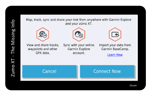
There's nothing wrong with Garmin Explore if it offers you a solution, but it changes the behvaiour of your XT which makes it difficult to get to grips with the basics.
As @Peobody mentioned - loading tracks and routes on the same screen gets you out of all sorts of problems if your route has been recalculated and you really wanted to follow your original. I do it all of the time with my XT. There is a section in my notes in section 6.
Here is a link to the fully linked contents page.
app.php/ZXT-P02
Then start it up and go through the set up procedures. Resist any invitations to set up Garmin Explore - which crops up when you first set things up and it implies that you must do it. Don't. Just select Cancel when you see this screen.
There's nothing wrong with Garmin Explore if it offers you a solution, but it changes the behvaiour of your XT which makes it difficult to get to grips with the basics.
As @Peobody mentioned - loading tracks and routes on the same screen gets you out of all sorts of problems if your route has been recalculated and you really wanted to follow your original. I do it all of the time with my XT. There is a section in my notes in section 6.
Here is a link to the fully linked contents page.
app.php/ZXT-P02
Have owned Zumo 550, 660 == Now have Zumo XT2, XT, 595, 590, Headache
Use Basecamp (mainly), MyRouteApp (sometimes), Competent with Tread for XT2, Can use Explore for XT - but it offers nothing that I want !
Links: Zumo 590s . Zumo XT & BC . Zumo Navigation Booklet . Zumo XT2
Use Basecamp (mainly), MyRouteApp (sometimes), Competent with Tread for XT2, Can use Explore for XT - but it offers nothing that I want !
Links: Zumo 590s . Zumo XT & BC . Zumo Navigation Booklet . Zumo XT2
-
danham
- Posts: 412
- Joined: Fri Jul 13, 2018 2:25 pm
- Location: Cape Cod, MA
- Has liked: 148 times
- Been liked: 139 times
Re: Suggested reading, please
@jfheath,
Thanks! I have read your entire tutorial and will keep using it as a refernce. Really helpful.
The guy I'm buying the XT from is very savvy and says he is doing a full reset. So I assume it will start up and show the setup screen(s). If not, I'll do one.
I very much like the idea of showing the track while running a route -- seems like best of both worlds: a guide that can't change, combined with turn directions displayed with mileage, plus two ways to get back on course if a detour is necessary.
-dan
Zumo XT, 660, nuvi 760 and many retired units dating back to the GPS III+
2018 Kawasaki Ninja H2 SX SE
2018 Kawasaki Ninja H2 SX SE
Re: Suggested reading, please
- I'm carefull with the USB connector, I use it as little as possible.danham wrote: Thu Feb 02, 2023 12:04 pm Is there a reason you prefer to use a wireless transfer? I'm open to suggestions.
- You will need, some kind of, a PC to transfer your routes via USB. 'On the road' that might not be available.
- With Google Drive you also have the option to save an 'offline copy' on your phone, should an Internet connection be not possible. So you allways have it available everywhere.
See this thread and the PDF that I uploaded. viewtopic.php?t=2083
Note: You may like Google Drive, Microsofts Onedrive has the same functions
-
danham
- Posts: 412
- Joined: Fri Jul 13, 2018 2:25 pm
- Location: Cape Cod, MA
- Has liked: 148 times
- Been liked: 139 times
Re: Suggested reading, please
Thanks. Good points. But if I have routes and tracks on the SD card, no need for any connection, as I can mount the card on my computer to load it with routes/tracks before leaving home. Am I missing an important point here?FrankB wrote: Thu Feb 02, 2023 1:01 pm- I'm carefull with the USB connector, I use it as little as possible.danham wrote: Thu Feb 02, 2023 12:04 pm Is there a reason you prefer to use a wireless transfer? I'm open to suggestions.
- You will need, some kind of, a PC to transfer your routes via USB. 'On the road' that might not be available.
- With Google Drive you also have the option to save an 'offline copy' on your phone, should an Internet connection be not possible. So you allways have it available everywhere.
-dan
Zumo XT, 660, nuvi 760 and many retired units dating back to the GPS III+
2018 Kawasaki Ninja H2 SX SE
2018 Kawasaki Ninja H2 SX SE