Page 2 of 3
Re: Wacko traffic auto-recalc routing
Posted: Fri Sep 29, 2023 5:51 am
by FrankB
In my first reply I said "Garmin's unwillingless'. Maybe it's 'inability'.
Re: Wacko traffic auto-recalc routing
Posted: Fri Sep 29, 2023 8:51 am
by ledwardio
I've just come back from leading a small group through the Alps and Dolomites and I encountered this more than once. It sadly didn't have much comedy value at the time when we are pulled up at the side of the road trying to figure out what was going on

Combined with the XT trying to take us through closed roads, refusing to take us through open roads and constantly wanting to come off a road heading into a town centre through back streets to rejoin the road makes me fairly convinced that the XT will be heading to eBay soon.
And yes, Drive app was connected, phone had signal and getting data, recalcs on prompted etc. The unit is a mess, with a lovely screen

Re: Wacko traffic auto-recalc routing
Posted: Fri Sep 29, 2023 9:33 am
by Rofor
The unit itself is not a mess - the way, Garmin's firmware uses it, is a mess!
They had a good working routing algorithm in the Zumo 59x/39x series before, but their unprofessionell try's to make it better and better and their ignorance of the customers wishes make it more and more worse - until firmware 2.90 the Zumo XT works well, but than came the 'join' with the Tread series and up from firmware 5.90 the problems getting worse and worser. Instead of listing to the users, they gave us support for 'backward cameras' and for 'power switching units' - both things enormous important for motorbikes!

I'm done with hoping for the better - i'm using my Zumo XT for pre-Planned routes with Basecamp, automatic recalculation is turned off, traffic information is turned off. This way it works very good for me - and for point-to-point navigation i'm using Google Maps. As i said before, should the Zumo XT 'die', i will use one of this new units supporting Android Auto/IOS Carplay - Osmand+ is already working for Android Auto and i'm hoping, that the 'Kurviger.de' app already will be in not too long time....
Re: Wacko traffic auto-recalc routing
Posted: Fri Sep 29, 2023 10:50 am
by ledwardio
The Software/Firmware is integral to the Hardware so as a whole it's a mess
It does feel that the latest software has introduced more problems than it attempted to fix - doesn't instil much confidence in Garmin or the unit.
All the routes on my trip were rigorously pre-planned with Basecamp rather than point-to-point. luckily this meant the times it went crazy as per the original poster I managed to continue my original route by memory (no mean feat, so probably more luck) and continue.
Re: Wacko traffic auto-recalc routing
Posted: Fri Sep 29, 2023 1:17 pm
by Peobody
As annoying, frustrating, or humorous the XT can be, there are workarounds (tips and tricks) that can reduce their impact on the riding of a preplanned route. These are the ones that come to mind for me.
- Create a track on the route and have it showing on the map.
- Import each route, make sure it loads, check it for accuracy, do the mimport fix.
- Check the remainder of the route for changes following any recalculation (compare the route line to the track line). If it was changed, stop the route and restart it.
- Have enough Via points in the route so that there is always one within reasonable distance that you can select as an entry point should you need to.
- Have a copy of the route on the SD card for re-import should you need to.
- Set recalculation to 'Off' or "Prompted".
- I am sitting on the fence about Traffic. The auto reroute reaction to detected road closures is horrendous. The notification about slowdowns ahead has been valuable in some cases, totally wrong in others. I think I prefer seeing it and then doing my own assessment although it won't take many more bad experiences for me to turn it off.
Re: Wacko traffic auto-recalc routing
Posted: Fri Sep 29, 2023 10:13 pm
by rbentnail
Peobody wrote: Tue Sep 26, 2023 10:40 pm
I returned home from a ride about an hour ago. Priority one was to share a screenshot of insane routing that occurred when the XT reacted to a road closure ahead. I was heading West to East. The road closure was offscreen a little bit to the West. The black line is the track of my intended route.
I am posting this solely for its humor value. Well, maybe for its absurdity too.
Screenshot of wacko traffic recalc.png
Looks perfectly logical to me. The XT is re-routing what it believes to be a closure. But you have forced it to visit each point on your original route so that's all it's doing- taking you from the calculated route, to a point, then back again. Repeatedly. Is it not as simple as skipping the points?
Re: Wacko traffic auto-recalc routing
Posted: Sat Sep 30, 2023 12:04 am
by Peobody
rbentnail wrote: Fri Sep 29, 2023 10:13 pm
Is it not as simple as skipping the points?
They were points that I wanted to ride through so I did not want to skip them. This speaks to the issue of the XT being lousy at handling pre-planned routes. Ideally the reroute should have routed around the closure to the next via point and then continued following the preplanned route. Also notice that the routing to and returning from each point is Direct routing. The XT was in Motorcycle profile as were each of the points so Direct routing should not have occurred. This route it produced could not have physically been ridden.
If you look at the image, the closure was at the stream on NC182 between the "NC182" oval and the town of Johnstown. The reroute done by his Nav6 took us north, the east on Flay Rd, then south to Johnstown through all of the via points. That route was logical and rideable. The one the XT produced was neither.
Re: Wacko traffic auto-recalc routing
Posted: Sat Sep 30, 2023 7:06 am
by jfheath
Interesting thoughts, comments and observations.
I have traffic turned on most of the time. I'm normally in areas that I know well, so am building up a mental picture of how it behaves. I now know for certain that the location of traffic and road closures cannot be relied upon. Some closures are only for overnight work; Some are flagged as being on a road rather than at a location - so the entire area is unnecessarily avoided; Some closures are for a cyle ride on Sunday morning next week. What they do flag up is that something may affect my route, so I get onto the AA roadwatch site here in the UK and investigate, and back it up with searches for the official notices. But only if it is a long ride which is reaching my daily limit.
Not relevant, but fun:-
Some 'closures' are lies. We have a road near us, down into the village, which is quite narrow, quite steep, and often lined with parked cars. It is effectively a variable one way street. The permitted direction is determined by the vehicle that arrives first. But non-locals who try to use it as a rat run to avoid queuing traffic on the main roads, do not know what they are hurtling into. Great fun in winter when the cars hit the icy, un-gritted section and expect their brakes to be effective..
The OSM maps which are used by many mapping providers, including those used by Garmin, have a website where it is possible to add information and make corrections. A bit like you can on Wikipedia. i think the locals got fed up with head on altercations and traffic using the narrow pavement literally on their doorstep, because somehow the Garmin maps will no longer navigate down this road.
It is not the Zumo algorithm. The OSM map has changed to indicate that there is no way to travel the entire length. Almost as effective as erecting bollards, but without the need for planning permission. I thought about correcting it, but decided that I quite like having that road not being used by speeding short cut takers. Especially since it is now the walking route to school. (They built a new school in a different location).
It is possible that similar map adjustments happening all over the place.
I always take the most recent road maps with me.
Re: Wacko traffic auto-recalc routing
Posted: Sat Sep 30, 2023 1:04 pm
by Peobody
jfheath wrote: Sat Sep 30, 2023 7:06 am
I have traffic turned on most of the time. I'm normally in areas that I know well, so am building up a mental picture of how it behaves. I now know for certain that the location of traffic and road closures cannot be relied upon. Some closures are only for overnight work; Some are flagged as being on a road rather than at a location - so the entire area is unnecessarily avoided; Some closures are for a cyle ride on Sunday morning next week. What they do flag up is that something may affect my route, so I get onto the AA roadwatch site here in the UK and investigate, and back it up with searches for the official notices. But only if it is a long ride which is reaching my daily limit.
Google maps plays a big part in my planning so I route around closures known to it. The closure I encountered last week was a new one. I had ridden the same route a couple of months ago without issue. When I receive a traffic notification I visually survey the area, look at traffic movement and alternative routes, then decide what to do. I DO wish that road closures were handled in the same way as traffic slowdowns rather than an automatic reroute with no visual notification. This will never happen though, especially not that there is a lawsuit against Google Maps for routing down a closed road (bridge washed out) that resulted in a death. Adding credence to the lawsuit is that Mapquest showed the road closed. From what I've heard, the driver drove past "road closed" barricades separated enough for a car to go through. I hope to hear how this turns out but I suspect it will die quietly in a monetary settlement.
jfheath wrote: Sat Sep 30, 2023 7:06 am
I always take the most recent road maps with me.
Me too. I maintain a bin of current state maps in my home office from which I stock the bike with the ones pertinent for the trip. I have needed them twice, once before satnav when navigating by phone and loosing cell service, and once when an incident occurred that required I find the closest large city when riding through southeastern Oklahoma.
Re: Wacko traffic auto-recalc routing
Posted: Sat Sep 30, 2023 9:43 pm
by Rofor
rbentnail wrote: Fri Sep 29, 2023 10:13 pm
Looks perfectly logical to me. The XT is re-routing what it believes to be a closure. But you have forced it to visit each point on your original route so that's all it's doing- taking you from the calculated route, to a point, then back again. Repeatedly. Is it not as simple as skipping the points?
For sure this can't be the only reason for this zig-zag weirdness re-routing!
In my example from 2021, that i've posted above, there wasn't any via- or waypoint in the pre-planned route, only shaping-points and i got the same stupid zig-zag course with an extra of around 100km(!) after such a road-closed-rerouting....
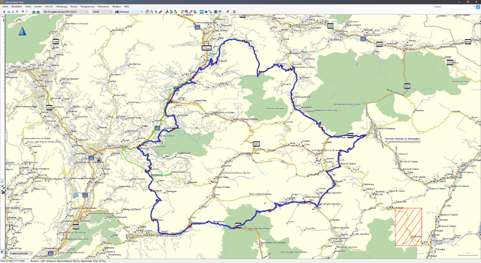
- This was the pre-planned route (blue) and my driven track (green)
- 2023-09-30.png (1.27 MiB) Viewed 2280 times
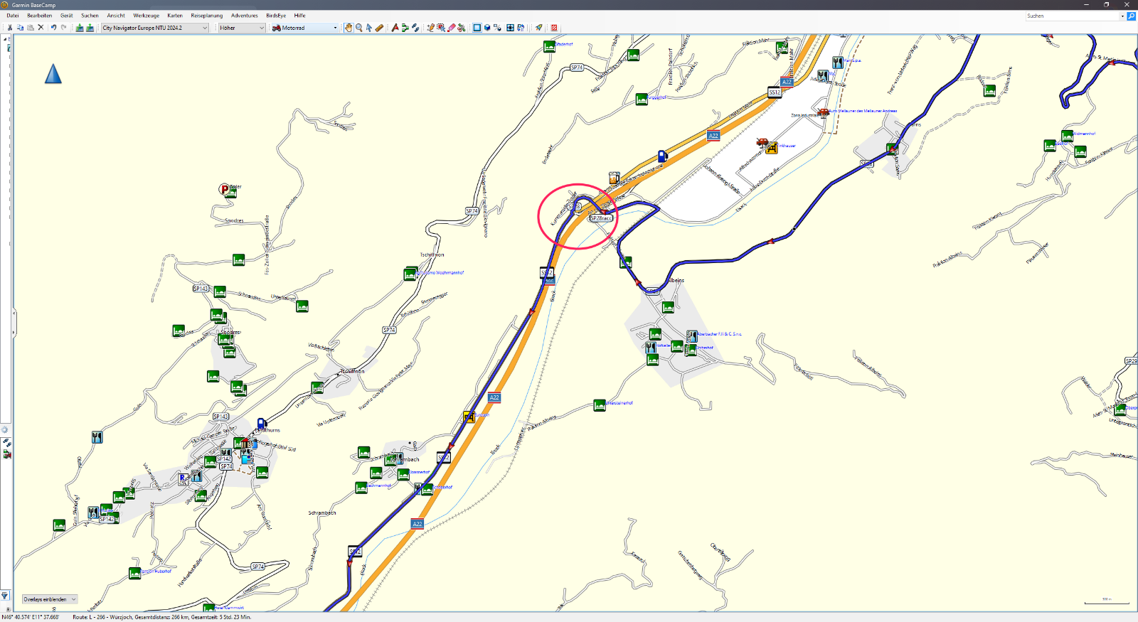
- Red marker shows the place, where the re-routing occurs
- 2023-09-30 (1).png (543.34 KiB) Viewed 2280 times
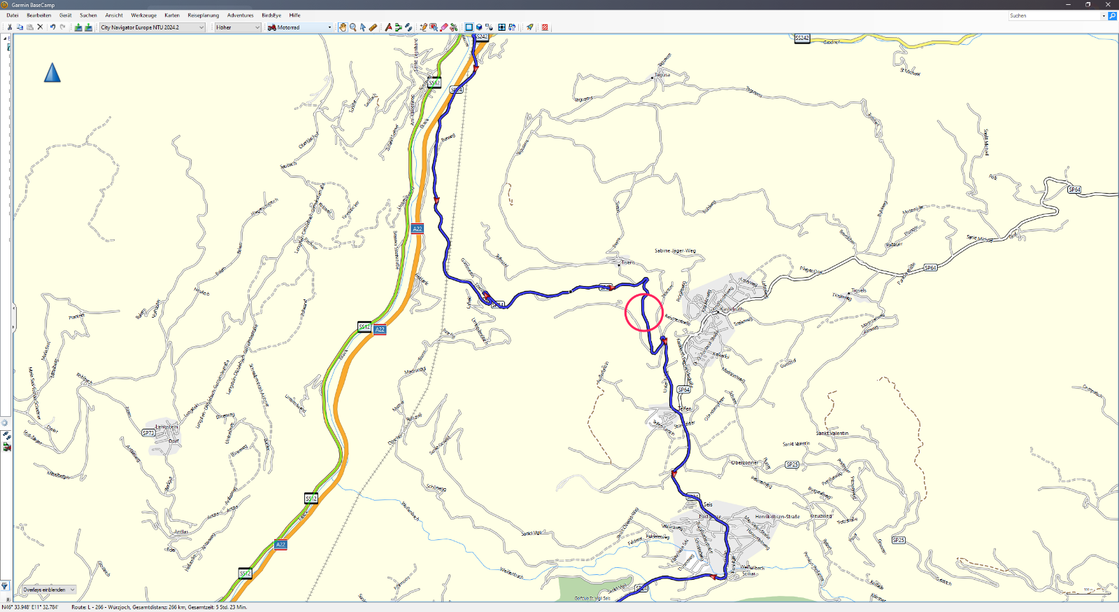
- Red marker shows the (not really) closed road
- 2023-09-30 (2).png (662.54 KiB) Viewed 2280 times
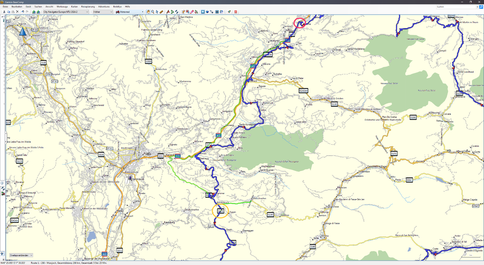
- And again - red marker where the re-routing starts, orange marker our hotel...
- 2023-09-30 (3).png (1.2 MiB) Viewed 2280 times