I have done a fair bit of testing with v2.90 firmware, and I have to say that Closest Entry Point is the best that I have seen this feature operate to date.
But I have tested v2.90 before, soon after it came out, and I was less than impressed. This may have been circumstantial, but worth noting is that since that test I have used Garmin Express to update 3 files which I believe should not affect the software function. Text Translation, Cyclopse updates and the like. Also Garmin Express needed an update twice on consecutive days - I have V 7.1.2.0, installed earlier this week. I just loaded it to read the version number and a new version 7.1.3.0 is now avaliable.
After those updates I tried these lengthy tests and Closest Entry Point was working (almost) very predictably).
I used Basecamp to create the route and to transfer it Via USB cable to the Zumo XT.
What I found was:
The CEP function attempts to navigate the rider from the current position to the closest point on the route.
This is irrespective of location of Shaping Points or Via Points. It picks a point on the planned route and heads for that
It then continues along the planned route follwoing the shaping points and Via Points in the correct order.
It ignores any Shaping Points and Via Points that are behind the point of entry.
I looked for, but found no difference in behaviour for any routing point that was first created as a Waypoint, or a routepoint that was 'dropped' into place using the insert tool or the route tool. This odd behaviour had been observed in a previous version of the XT's firmware.
One unexplained anomaly
On a few occasions, the CEP function calculated a perfectly sensible route, but it did not head for the closest route point. AFter much messing around, it seems that when this happened, If I forced a recalculation of the route by (say) ticking / unticking U-turn as an avoidance and loading the route again to select the closest entry point, it produced a correct result. It didn't matter whether I ticked or unticked it, as long as it was changed so that the route recalculated when it was loaded. If I subsequently set it back to what it was, I still got the correct route.
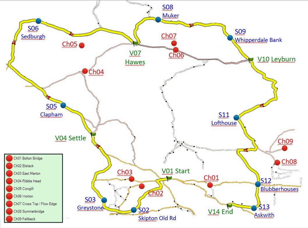
I have a simplified image of my test route shown below.
There are 5 Via Point (including start and finish) and 9 Shaping points. They are lettered V or S (Via, Shaping) and then numbered consecutively
eg V01 S02 S03 V04 S05 ... etc.
There are also a number of Check Points - places to position the bike to test what the stanav will do when the route is started from there and Closest Entry Point is selected. These are labelled Ch01 Ch02 Ch03 Ch04 ......etc. I have created these as Waypoints so that they are plotted on the map, but do not appear in the route itself.
All of these along with the shaping points, via points and the route itself are included in the attached gpx file.
(Modified from the original gdb file - 30 Aug 2020)
The route was created using City Navigator Europe NTU 2021.10
I've run out of time. I intended to post a map of the results, but anyone that wants to do their own testing to see if we share the same result - you now have the same tools that I used. I'm not saying that these findings are definitive - but they are still findings, and Iafter carrying out these tests, I have a lot mor confidence in using it.
I have a document which describes and illustrates each of the tests from each of the Ch check points - but it needs thoroughly checking over before I publish that.
Simplified Image of the Test Route

- Simplified Im age of the Route.
- CEP Test Map Route and Points.jpg (127.05 KiB) Viewed 2557 times
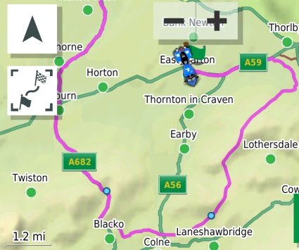
Nb All of these tests were carried out on a Zumo XT, using BAsecamp while sitting at my desk. This is perfectly acceptable and does not require any testing in the field. As soon as you select GO! and then choose closest entry point, the Zumo draws a map on the screen. The map shows all of the blue circle shaping points, and the flag Via Points. It draws the route to be travelled from the current position onwards. You can see which shaping points and via points have been missed out. Here is one such, where the closest entry point is to the right of the map and the shaping points are clearly visible. The start of the route is not shown - at this stage of the trip, it is irrelevant.

- Eg Route.jpg (32.7 KiB) Viewed 2557 times
To carry out a simulated test.
Turn off GPS in the Navigation section. If at any time it asks if you wish to simulate riding, say no.
MAke sure that there isn't a route currently active. If there is, press 'X' Stop.
Before you do this, make sure you have transferred any routes that you need to have in the Zumo. Transferring them via USB will certainly turn GPS back on again when it restarts.
Show the map on the screen. Touch the screen, a blue flag will be placed where you touched. Ignore it. Press the arrowhead top left to put north at the top of the screen. If the arrow head isn't there, it will reappear when you touch the screen again. Try not to tocuh the flag - it opens up another window. Zoom Out (the minus key) . Scan around the map to find the area where you wish to place the motorbike, and zoom in (+) to find the exact location. Place the map precisely - zoom in as far as you need to and if you get it wrong tap somewhere else and have another go in the original place.
A message will appear at the bottom of the screen giving the name of the location. Check the flag is where you want it and tap the bar with the name on it. The screen will split into two halves - the right half shows the map, the left half shows detail, coordinats, arrival time and such like. Ignore all of that and press the down arrow at the left of the screen. Press it and a number of buttons pop up, one of which should be 'Set Location'.
Press it. (If it isn't there, then it is probably because you currently have a route running. Go back to the home screen at tap the X stop button. Start again.)
The motorcycle will now be in the location you selected. Back out, and if you view the map, te bike will be centred in that location on the map. 'GPS is Off' will appear across the top of the screen.
Warning - if you let the Zumo 'Time Out' it may turn the GPS back on again. Don't let it time out by puttin it down to go and make a cup of tea !
You can now load up the routes, say Go. and select Closest Entry Point. The map that comes up next is all that you need to see.
If you want to enable / disable U turns, back out to the main screen - alter the settings under Navigation and load the route again.