Page 4 of 10

Re: Travel planning tips – Basecamp and Zumo XT

Posted: Wed Apr 27, 2022 7:06 am
by jfheath
Raf wrote: Tue Apr 26, 2022 9:40 pm Or it is sufficient always have only one WP( home, hotel or other)
Yes, absolutley correct.

But it is so easy to delete the list of favourites from the XT screen, and if you do manage to do that, it is handy to know why you cannot import them again and that simply using the map to add a new favourite makes them all become available to import again.

Re: Travel planning tips – Basecamp and Zumo XT

Posted: Thu Apr 28, 2022 8:53 pm
by lkraus
I made one waypoint on my XT near my home, and edited the name to "Do Not Delete". So far, this has kept me from forgetting the necessity of keeping one waypoint during my regular purges. It's so easy to just select "All"...

I usually only keep a single day's route, track, and waypoints on my GPS. It greatly simplifies the use of the menus.

For multi-day trips, I create one file list per day in Basecamp, and use File>Export>Export Selection to put each list in a temporary location on the PC, and then copy them all to \zūmo XT\Memory Card\Garmin\GPX. This is more work, but the gpx file on the card will use the name of the list, which I find more useful than the generic "Route_.gpx" produced by the "Send to..." option.

I do also carry a small Windows netbook on longer trips. Plans always change, and planning with Basecamp is easier than using the XT. Researching alternate destinations is easier with a real keyboard and larger screen, too. Cloud storage (Dropbox) keeps the Basecamp database in sync with the home desktop.

Re: Travel planning tips – Basecamp and Zumo XT

Posted: Mon May 02, 2022 4:11 pm
by PhillH
Another option with waypoints is to give them a category i.e. Day1, Day2 etc then you can search by that category to see you options for the day.

Re: Travel planning tips – Basecamp and Zumo XT

Posted: Mon May 02, 2022 4:57 pm
by Raf
PhillH wrote: Mon May 02, 2022 4:11 pm Another option with waypoints is to give them a category i.e. Day1, Day2 etc then you can search by that category to see you options for the day.
I will do as you have you wrote
Advise : Give a category with Basecamp .It's much easier than doing it with the Zumo

Re: Travel planning tips – Basecamp and Zumo XT

Posted: Tue May 03, 2022 7:23 pm
by Fxwheels
To clarify what @jh wrote on page 3.
Please correct me if I'm wrong:
BaseCamp rules -
- A blue flag set on route = way point. It does not change its name in the XT (or 396), and will be saved in Saved or Favorites.
- If it is (flag) marked as "Alert on arrival" - it becomes a Via point
- If marked as "won't alert" - it behaves as a regular shaping point
- If it is NOT a flag, but a regular shaping point:
- if a name is given to it - can change the name in the nav (and will alert or won't alert depending on the selection).

And also, why in "Transferring routes" option, in your manual you've mentioned to uncheck all boxes including "Always match route to the map on my device when transferring"? Don't you want to mach the transferring route with the device's map, or something I don't understand here?

Thanks.

Re: Travel planning tips – Basecamp and Zumo XT

Posted: Tue May 03, 2022 10:40 pm
by jfheath
Fxwheels wrote: Tue May 03, 2022 7:23 pm To clarify what @jh wrote on page 3.
Please correct me if I'm wrong:

BaseCamp rules -
- A blue flag set on route = way point. It does not change its name in the XT (or 396), and will be saved in Saved or Favorites.
Not quite right with the first point. But I can see why you would think that - it seems to come up with a blue flag by default. But any point can be assigned the blue flag, and any waypoint can be assigned any other symbol offered in the properties dialogue box.
The only definitive way to spot whether a point was created as a waypoint on Basecamp is that it appears in the bottom left window pane along with routes and tracks. Yes Waypoints are save in Favourites or in 'Saved'. Name change, yes that is correct, and is covered below.

On the Zumo XT Via Points are alwas shown as flags. Shaping points are always shown as blue discs. Waypoints are not identifiable at all, but you can display a symbol to identify them if you wish.
Fxwheels wrote: Tue May 03, 2022 7:23 pm - If it is (flag) marked as "Alert on arrival" - it becomes a Via point
Yes, that is correct. But in Basecamp it doesn't have to be a point identified with a flag. Any point can be marked as alert on arrival, and it then becomes a Via Point. It doesn't become a waypoint though if it wasn't created as a waypoint.
Fxwheels wrote: Tue May 03, 2022 7:23 pm - If marked as "won't alert" - it behaves as a regular shaping point
Again, any point on a route can be set to be non alerting. That is a Shaping Point. Waypoints can be made into shaping points.
Fxwheels wrote: Tue May 03, 2022 7:23 pm - If it is NOT a flag, but a regular shaping point:
- if a name is given to it - can change the name in the nav (and will alert or won't alert depending on the selection).
Almost. If it is not a Waypoint the transfer process may change the name of the point. It never seems to change the name of a point created with the waypoint flag tool in Basecamp. It doesn't always change the name of non-waypoints. Maybe a bit more that half of the time. I have yet to discover the circumstances. This is not unique to the XT. It also happened on the 595, but not on the 590.
(I think that the XT takes the coordinates, and then uses its internal database to find a name near to that point. If it can't find one, it keeps the name you allocated. But that is only a working theory yet to be proved or disproved).
Fxwheels wrote: Tue May 03, 2022 7:23 pm And also, why in "Transferring routes" option, in your manual you've mentioned to uncheck all boxes including "Always match route to the map on my device when transferring"? Don't you want to match the transferring route with the device's map, or something I don't understand here?
If you always match, my observation is that the XT will always recalculates the Basecamp route for itself. This can take a long time when importing the routes. If you don't match, the the XT will keep exactly the route that you planned in Basecamp. Unless you deviate from the route and auto recalculate is allowed. I assume that you know that the maps are the same in Basecamp and on your XT. If they are not, then yes - you want the XT to recalculate the route.

This is not the big issue that it was, since the XT seems to want to recalculate the route in many different situations. eg Traffic ahead - but that can be turned off. So you may wish to have it recalculate your route so that you can see what it is different.

Me - I transfer the route and a track, and show both on the screen at the same time. I allow recalculation, but if the magenta line differs from my black track, I'll follow the black track - because that was where I wanted to go. (it also teaches me how much the XT recalculates my route and when).
Re: Travel planning tips – Basecamp and Zumo XT

Posted: Wed May 04, 2022 9:08 pm
by Fxwheels
jfheath wrote: Tue May 03, 2022 10:40 pm If you always match, my observation is that the XT will always recalculates the Basecamp route for itself. This can take a long time when importing the routes. If you don't match, the the XT will keep exactly the route that you planned in Basecamp. Unless you deviate from the route and auto recalculate is allowed. I assume that you know that the maps are the same in Basecamp and on your XT. If they are not, then yes - you want the XT to recalculate the route.

Me - I transfer the route and a track, and show both on the screen at the same time. I allow recalculation, but if the magenta line differs from my black track, I'll follow the black track - because that was where I wanted to go. (it also teaches me how much the XT recalculates my route and when).
I wonder how Garmin would handle if the avoiding settings in it deffer from the BaseCamp's settings (for any reason), add to it weather the box was checked in or not...

I also like having track with route running. At one point Garmin led a different way and I didn't know why. When I got to it, I saw the road was a closed off trail... I took a magenta line :)

Re: Travel planning tips – Basecamp and Zumo XT

Posted: Sun May 08, 2022 11:13 pm
by jfheath
Fxwheels wrote: Wed May 04, 2022 9:08 pm I wonder how Garmin would handle if the avoiding settings in it deffer from the BaseCamp's settings (for any reason), add to it weather the box was checked in or not...
Basecamp calculates a route between all of the route points according to
Routing preferences (say faster time)
and any avoidances that are set.

When the route is sent to the XT it sends the entire route, exactly as the route is plotted in Basecamp.
It sends the vehicle profile name
It sends the routing preference ( eg faster time)
It does not send any of the avoidances that were set in Basecamp.

The XT should not recalculate this route when it receives it. The magenta line will follow exactly the same roads that was produced in Basecamp. The XT will not alter it.

But the XT does like to recalculate routes. It will do this if you deviate from the route or if you press Skip, or if it is set to re-route if it encounters traffic up ahead. All of these can be prevented, by turning off various options.

But if it does re-calculate the route, it does so using the routing preference that was set in the route from Basecamp ( eg faster)
And it uses any avoidances that are set in the Zumo for the vehicle that is named in the route. ( eg the avoidances set for motorcycle).
It a also uses the profile that you have built up - simply by riding with your satnav turned on - it can then use the type of roads that you like to ride.

Basically, although it receives the same route that was plotted in Basecamp, there is a pretty good chance that the XT will recalculate it at some time using very different rules from those that were set when it was first created in Basecamp. ***

Knowing this can really help you to decide where to out routing points, as it always has to pass through those.

Re: Travel planning tips – Basecamp and Zumo XT

Posted: Mon May 09, 2022 11:26 am
by communicator
I'm taking a group of friends (11 people and 6 bikes) for a road trip in Ireland in June 2022.
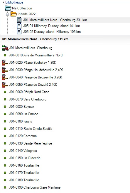
To realize my itineraries, I adopt a numbering for each road book like this.
For the 1st day, each point of passage on the map will be noted Jxx-zzzz

- xx will be the day number of the road trip
- zzzz will be a numbering starting from 0010 (starting point) to the arrival point going from 10 to 10
this gives for a one day road book with less than 29 waypoints

Example of a one day road book :
Image

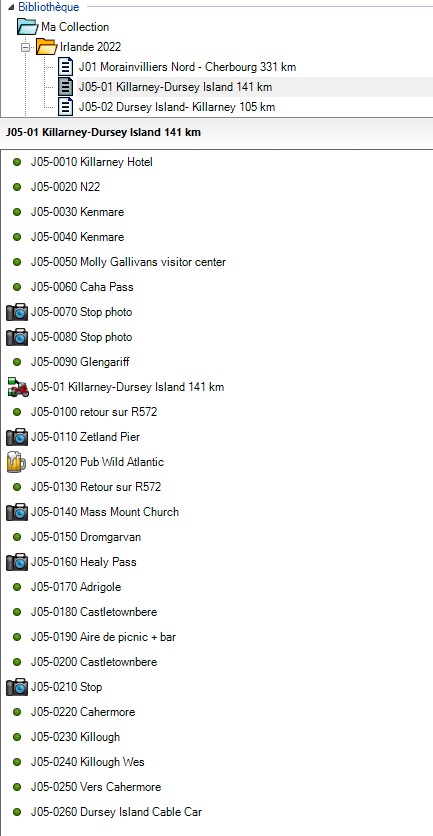
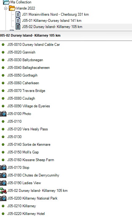
In case there are more than 29 waypoints, and to avoid that the GPS cuts the road book in 2 or 3 segments, I divide the road book of the day in x road book.
I always make sure that the change of road book corresponds either to a fuel stop or to a lunch stop.

Example of road book divided in 2 :
ImageImage

Re: Travel planning tips – Basecamp and Zumo XT

Posted: Mon May 09, 2022 12:24 pm
by jfheath
communicator wrote: Mon May 09, 2022 11:26 am

In case there are more than 29 waypoints, and to avoid that the GPS cuts the road book in 2 or 3 segments, I divide the road book of the day in x road book.
I always make sure that the change of road book corresponds either to a fuel stop or to a lunch stop.

From your image above, which I can see has been taken from Basecamp, I can see that you have 29 Waypoints created.

But your limit of 29 Waypoints is not correct. I believe that the limit is 29 Via points, rather than 29 Waypoints. It is true that when you first add a Waypoint to a route in Basecamp, it is added as a Via Point (ie alerts on arrival).
However, any Waypoint can be made into a Shaping Point. Any Shaping point can be made into a Via Point.

But a Waypoint is a point that has been created and saved before the route is created. An 'ordinary' route point cannot be made into a Waypoint'
It may or may not be included in a route.

The confusion comes because many mapping programs use the term Waypoint to refer to any point on the route. Garmin defines it differently.

Via Points have some advantages over shaping points.
They alert on arrival.
They display in the list of destinations that are displayed when you first select Go
They can display time / distance / duration to arrival in the Trip Datat display that can be added tot he right hand side of a landscaper screen.

But Shaping points are more flexible, in that if you miss one out but continue along the route after that shaping point, the XT will not take you back to it.

So your issue of splitting the route into two can also be solved by selecting some of your Via Points and changing them to Shaping Points.
The limit is 29 Via Points per route. (XT may allow 30 for a route that doesn't have to be split).
You can have 125 shaping points in between each pair of Via Points.


For the XT I use Waypoints for most of my route points now. The reason is that the XT will never change the name that I have allocated to a Waypoint. It (seemingly) randomly changes the name of other route points.
I change all of them to Shaping points. Then I choose s few (3-5) that I want to be stopping places and switch those back to Via Points.
(Start and End are always Via Points).