Page 7 of 8

Re: Is this RUT?

Posted: Mon Aug 26, 2024 8:35 am
by Sean OZ
jfheath wrote: Mon Aug 26, 2024 6:12 am The Zumo has a flag that lets it know whether a route has been created and saved on the Zumo or whether it has been imported. For the XT1, we had a method to change that flag - and it cured the problem. The same method works on the XT2.
Thanks, Jf for helping all of us "newbies" to get our head around the XT2. You mentioned that "The Zumo has a flag that lets it know whether a route has been created and saved on the Zumo or whether it has been imported" Out of curiosity, how do you "see" this "flag" you mentioned, on a XT2 please?

Re: Is this RUT?

Posted: Mon Aug 26, 2024 8:59 am
by jfheath
Thank you for feeding back about this. It will be good to have your confirmation.

But I have tested the XT on all of the test routes where I first identified the RUT issue and discovered the circumsatnces where it happens.
The XT2 behaves slightly differently with routes from BAsecamp - but still displays the RUT behaviour exactly the same as the XT1 on one test route, and on other test routes it displayed the RUT behaviour - but gave in earlier than the XT1 gave in. The XT1 used to give in when the original route was less than a mile ahead. The XT2 gave in once the original route was closer than the distance back to the original point of deviation. (I can't believe that is what it calculates - but that is what I noticed about the XT2.

But in every single test, the copied route has behaved perfectly. Sometimes continuing the way I was traveling immediately. Sometimes wanting U turns - because to U turn was actually the faster way to go, but then calculating ahead well before it reached the 'tipping point' - the place where continuin ahead is faster than turning back. I notice that the XT2 seems to have a limit on the number of U turn requestes that it makes.

It helps if before you go out on a test - know where you are going to deviate. And find out where the tipping point is. Where it is faster to continue ahead than it is to go back. Because it is only when you have gone past the tipping point and the Zumo is still asking you to go back, can you that there might be a RUT scenario.

But I'm looking forward to your results. The more tests the better. What bothers me is that this Copy solution might be unintended - and if Garmin read these posts they might decide to 'fix' it in a future software update - because the Copied route will not behave the same as the original !!

Fortunatelt, there is a roll back facility for updates.

Re: Is this RUT?

Posted: Mon Aug 26, 2024 9:23 am
by Sean OZ
jfheath wrote: Mon Aug 26, 2024 8:59 am
It helps if before you go out on a test - know where you are going to deviate. And find out where the tipping point is. Where it is faster to continue ahead than it is to go back. Because it is only when you have gone past the tipping point and the Zumo is still asking you to go back, can you say that there might be a RUT scenario.
Will certainly follow your advice mate.

Re: Is this RUT?

Posted: Wed Aug 28, 2024 8:56 am
by Sean OZ
@jfheath

Unfortunately, just making a copy of the original imported GPX route file, from BaseCamp and then using the Zumo XT2 "Copy" function, (giving the copied GPX file a new name), didn't work for me. I still ended up running into dam RUT problems. :cry:

The first screen shot shows how I planned the route in BaseCamp. From "Byangum Rd" to "222 Stokers Rd" Magenta line is how I planned the route in BaseCamp, and the Green line, is the road I purposefully deviated onto. Blue flags are Waypoints.
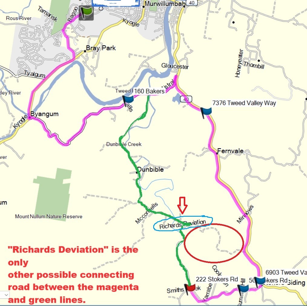
Magenta line is the original route created in BaseCamp. Green line is the road I deviated onto.
Failed RUT Test.jpg (192.81 KiB) Viewed 1678 times
Everything went well to begin with. This screen shot shows how BaseCamp organised it all.
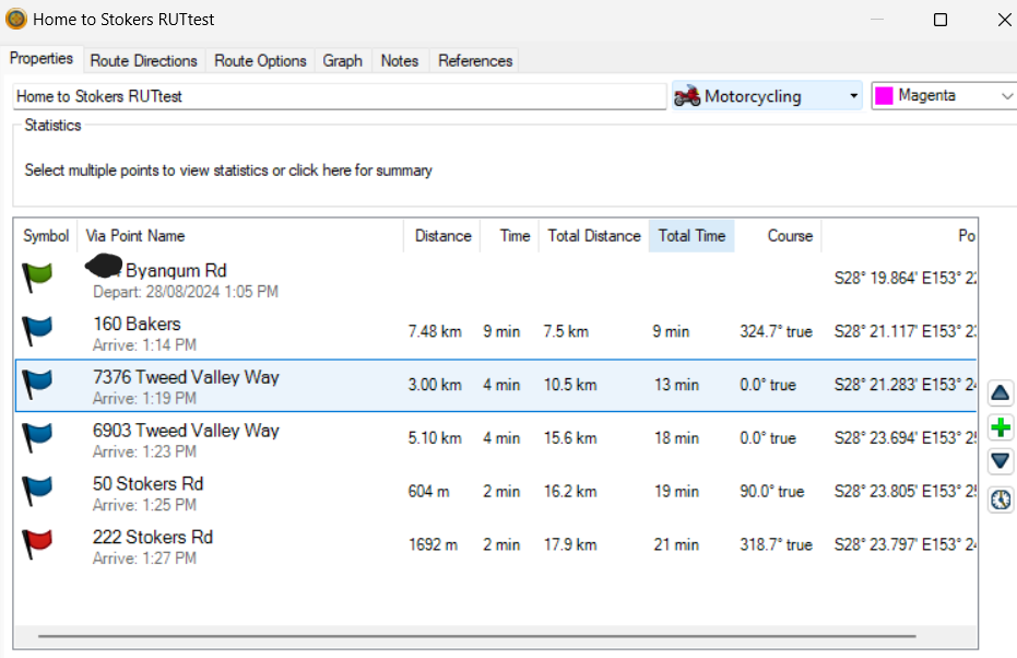
Details from Base Camp Program.
Details Failed Rut Test.png (153.98 KiB) Viewed 1678 times


This is the "turns" directions at the beginning of the route.
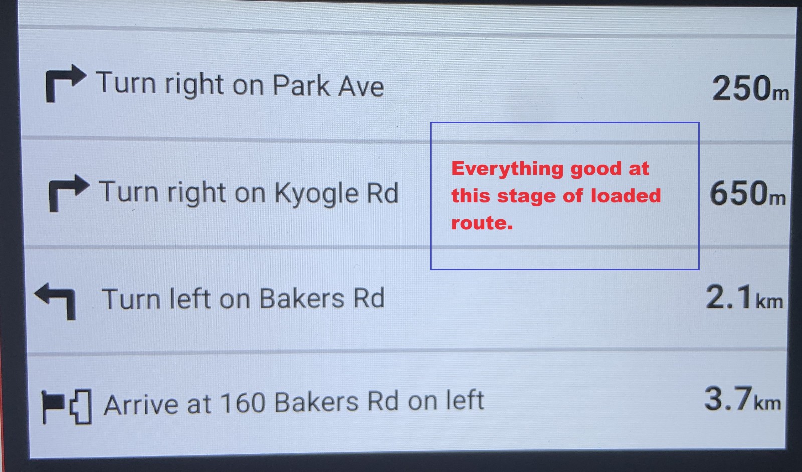
Turns directions to Bakers Rd
IMG_6893.JPG (306.27 KiB) Viewed 1678 times

This is a photo from the XT2 at the beginning of the ride
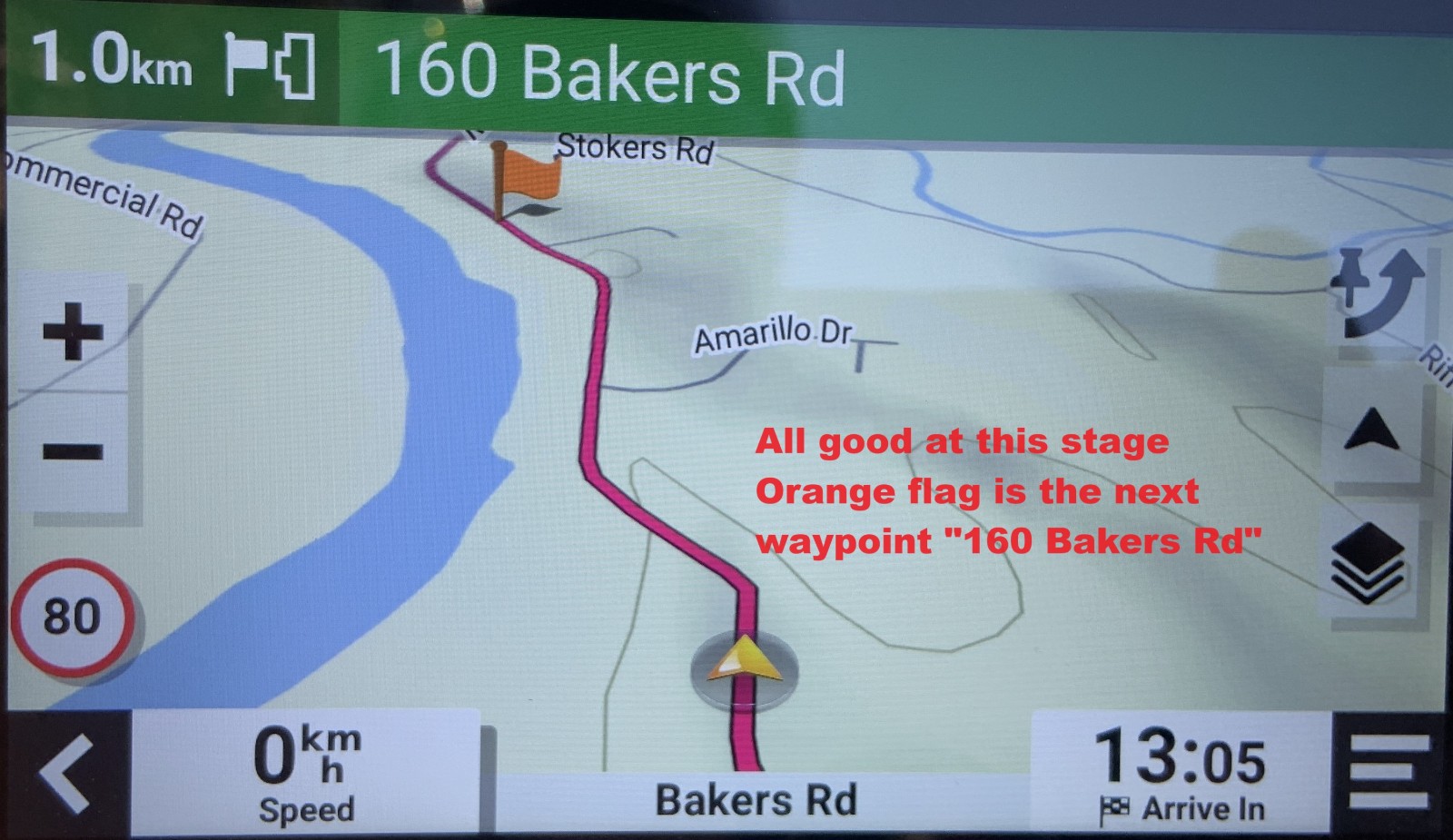
All Good so far
All Good so far
IMG_6890_edited.JPG (274.61 KiB) Viewed 1678 times


I continue to follow the directions to the next way point "160 Bakers Rd" no problems encountered. Once I have passed through the Bakers Rd way point, these are the next directions on the XT2
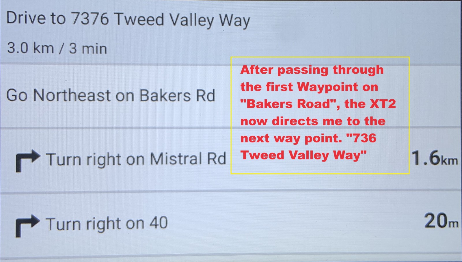
Directions to TVW
Directions to TVW
IMG_6894_edited.JPG (272.79 KiB) Viewed 1678 times

It's just after the Bakers Road waypoint, that I purposefully deviate from the instructed route (the magenta line) and instead turn off on to another road (The "Green" line shown in the very first photo)

It's at this point the ZUMO XT2 starts showing RUT behavior. Once more! :roll: within under a minute the XT2 starts telling me to make a U-Turn. I ignore it, but for the next 5KMs and more (whilst riding the green line) it kept insisting that I make a bloody stupid U-Turn and get my ass back to "7376 Tweed Valley Way". It made absolutely no sense to me, (wanting me to do a U-Turn) as by this stage I was definitely a lot closer to the final destination following the green line, than going back through the "7376 Tweed Valley Way" waypoint (on the magenta route line)

So I then tried something different, after the XT2 tried to route me along the "Richards Deviation Rd". (Circled in red in the first photo), I pulled over about 2kms from what was planned as my final destination. I Stopped the route and re-loaded the same route again. I then told the XT2 to start from closest entry point, which it the quite happily did so. (closest entry point being me on the green line and about 2 Kms from the final destination.

As I got closer to the "222 Stokers Rd" end point It kept asking me if I wanted to skip the waypoint I had previously ignored back at "7376 Tweed Valley Way" I ignored its advice and did not use the skip function.

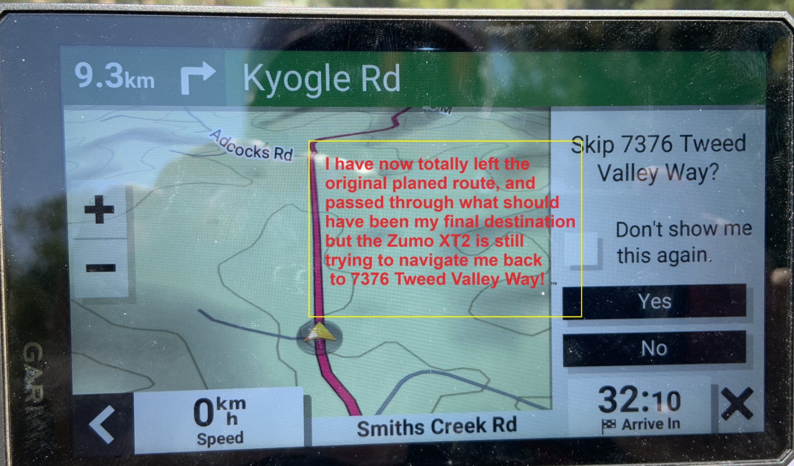
Even after I passed through what should have been the end waypoint, it still kept trying to direct me all the way back to the 7376 waypoint that I had previously just ignored.

Here's some more photos to show what happened...
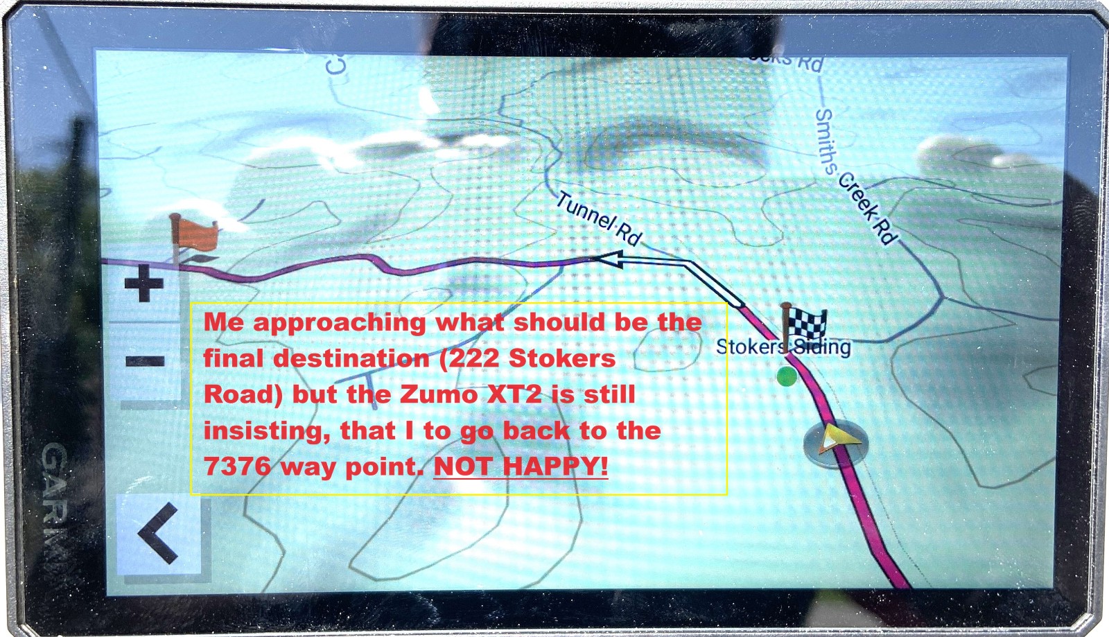
What should be the end point.
IMG_6891_edited.JPG (483.68 KiB) Viewed 1678 times
Still trying to re-route me!
IMG_6892.JPG (332.11 KiB) Viewed 1678 times
I'd happily share with you the original BaseCamp GPX file info. Whilst I know a site to share it from, I haven't been able to work out how to get BaseCamp to give me the option of making a sharable GPX file. Any info would be good.

I actually rode the route twice to be sure that I was using the correct "copied" version of the planed route and ended up with the same RUT problems both times!

The only reason I was able to make it to my final intended destination, was because I'm familiar with the roads here. If not for that, then it would have been very confusing to most other riders, which direction they should follow.

At this point I have zero faith in the XT2 being able to recalculate an alternative route, when using an imported GPX route file, if the rider deviates from the original imported route.

Almost forgot to say, that the XT2 was configured with Off-Route Recalculation set to "Automatic" and under "Avoidances, U-Turns set to "Avoid"

What else can I say except it's an explicit version of Destination Calabria Look it up on YouTube. ;)

Re: Is this RUT?

Posted: Wed Aug 28, 2024 1:34 pm
by Peobody
Sean OZ wrote: Wed Aug 28, 2024 8:56 am As I got closer to the "222 Stokers Rd" end point It kept asking me if I wanted to skip the waypoint I had previously ignored back at "7376 Tweed Valley Way" I ignored its advice and did not use the skip function.

Even after I passed through what should have been the end waypoint, it still kept trying to direct me all the way back to the 7376 waypoint that I had previously just ignored.
This doesn't surprise me. The blue flag indicates that the 7376 waypoint is a Via point. IMHO, a satnav should insist on visiting a Via point unless explicitly told not to (eg: Skip). OTOH, a Shaping point should be ignored by the satnav when missed.
Sean OZ wrote: Wed Aug 28, 2024 8:56 am I haven't been able to work out how to get BaseCamp to give me the option of making a sharable GPX file. Any info would be good.
I just export the route to a location in my hard drive and then email the resulting .GPX file to my riding buddies.

Re: Is this RUT?

Posted: Wed Aug 28, 2024 4:50 pm
by jfheath
Many thanks @Sean OZ - I'll give your post a lot more scrutiny before I reply to that. I don't have that amount of time for a little while.

I just wanted to raise a couple of points from @Peobody's reply

Peobody wrote: Wed Aug 28, 2024 1:34 pm This doesn't surprise me. The blue flag indicates that the 7376 waypoint is a Via point. IMHO, a satnav should insist on visiting a Via point unless explicitly told not to (eg: Skip).

I don't think that I agree with this. But I am not sure. Is the copy of Basecamp in @Sean OZ's post a windows version or an Apple? There may be a difference of which I am unaware

On the windows version, The flags tend to pop up when a Waypoint is created, but not when an adhoc point is created. The colour of the flags can be changed when you edit the Waypoint. But you cannot assign an icon to an adhoc point. Only to a point that was already created - such as a Garmin POI or a Waypoint.

The only things that identifies a point in the route list as a Via point is that the text is black - not grey, and the fact it does not say "(won't alert)".
Example Here is a route list made entirely of Waypoints. As Waypoints I can set the icon to whatever I like - when I edit the Waypoint. So a mixture of symbols. Some of them are Shaping Points, some are Via Points. The symbol or colour of the flag is irrelevant.

I think that Sean Oz has created his all as Waypoints first. Partly because the couple that I can see have kept the name that he gave them when they were transferred to the Zumo (but that may be a false positive) - and partly because the symbols are not 'normal' for a route that has been created just by creating Waypoints. Not for the Windows version anyway.

temp.png
temp.png (45.43 KiB) Viewed 1650 times
Peobody wrote: Wed Aug 28, 2024 1:34 pm OTOH, a Shaping point should be ignored by the satnav when missed.
Put that tin-opener away. That's a real can of worms you have opened ! I'll try to be brief.

Generally speaking - if you miss a shaping point, the satnav will always try to take you back to it - or navigate ahead and find another way to visit it. It is on the route - it is under obligation to visit it.

UNLESS - you rejoin the magenta route that leads away from the shaping point. (ie you are on the recalculated route towards the shaping point. The other side of the shaping point has the route, still intact, after the shaping point. If you join that, then the satnav will stop asking you to visit the shaping point. But if you miss a detour - there and back - down a side road to a shaping point, you are back on the magenta line as soon as you don't turn. The XT doesn't miss a beat - it just continues ahead.


(These are XT observations - but after repeating the testing on the XT2 that I previously observed on the XT, so far the XT2 is behaving in the same way as the XT - but I haven't provoked it beyond those XT RUT tests.) If you press skip at any point then the nature of the route changes. THEN if you miss a road leading to a Via Point or to a Shaping Point, the XT will calculate a route that gets you onto the magenta line after the point that you jave skipped. In other words it is as if the route point never existed. It actually removes the point from the route - or to be precise, it redraws it without that missed point in place.

I've got videos of this happening on the XT. I've got part way through writing it up on the Zumo XT pages a few months ago. But I got sidetracked by the XT2. They are not visible yet. I'm happy to get back to this topic - because I haven't even tried to repeat this scenario with the XT2.

If you press Skip - all sorts of weird things can happen. It can be difficult teasing out exactly what is going on - which is why I want to take my time studying what might have happened in @Sean OZ's situation.

Re: Is this RUT?

Posted: Wed Aug 28, 2024 7:59 pm
by jfheath
Image

Sean OZ wrote: Wed Aug 28, 2024 8:56 am It's just after the Bakers Road waypoint, that I purposefully deviate from the instructed route (the magenta line) and instead turn off on to another road (The "Green" line shown in the very first photo)

It's at this point the ZUMO XT2 starts showing RUT behavior. Once more! :roll: within under a minute the XT2 starts telling me to make a U-Turn. I ignore it, but for the next 5KMs and more (whilst riding the green line) it kept insisting that I make a bloody stupid U-Turn and get my ass back to "7376 Tweed Valley Way". It made absolutely no sense to me, (wanting me to do a U-Turn) as by this stage I was definitely a lot closer to the final destination following the green line, than going back through the "7376 Tweed Valley Way" waypoint (on the magenta route line)
OK - this is definitely NOT RUT behaviour.

Just looking at the route list. You started the route. You passed 160 Bakers and then you deviated from the plotted route.

The next route point is Tweed Valley Way. That point may well be a Waypoint. You said that the Blue flags were all waypoints.
But when navigating a route it makes no difference whether or not the point was created as a Waypoint - except that the XT2 keeps the name that you gave it. What matters is whether it is a shaping point or a Via Point. And in this case it is a Via Point.

It doesn't matter how close you get to that chequered flag - the next point that the Zumo is trying to get to is that Via Point at 7376 Tweed Valley Way.
You could ride straight through the chequered flag - it still wouldn't navigate you to it. You MUST visit a Via point.

Thin change if you skip a route point earlier on, but you don't mention that you skipped a route point on this section of the test.
And actually - even if it was a shaping point the XT2 would still want to take you to it. That is its job. Not to get you to the end - but to follow the route visitng every point that you plot in the order that you plot them.

So you cannot criticise the Zumo for trying to take you to the next point that you have plotted ! You might criticse is for the route that it chooses - but on the map I think it is 50-50 whether going south first or going north first is the quickest way to get to the Tweed Valley Way Via Point.

I'll suggest a better way of testing RUT behaviour with that route tomorrow.


There are special circumstances with a shaping point - in that IF you happen to join the magenta line after the missed shaping point, it will then navigate you to the next one instead. (Although if you check the skip list, you'll find that the missed point is still listed.) That may be an issue with the second comment - but I'll come back to that tomorrow. Its late evening here now.

Many thanks for the detailed report of your trip. I'm enjoying looking through it. I don't mean to sound critical in any of the above. Just trying to explain. Come back to me on any of the above if you want.

Re: Is this RUT?

Posted: Wed Aug 28, 2024 10:47 pm
by jfheath
Sean OZ wrote: Wed Aug 28, 2024 8:56 am
So I then tried something different, after the XT2 tried to route me along the "Richards Deviation Rd". (Circled in red in the first photo), I pulled over about 2kms from what was planned as my final destination. I Stopped the route and re-loaded the same route again. I then told the XT2 to start from closest entry point, which it the quite happily did so. (closest entry point being me on the green line and about 2 Kms from the final destination.

As I got closer to the "222 Stokers Rd" end point It kept asking me if I wanted to skip the waypoint I had previously ignored back at "7376 Tweed Valley Way" I ignored its advice and did not use the skip function.

Even after I passed through what should have been the end waypoint, it still kept trying to direct me all the way back to the 7376 waypoint that I had previously just ignored.

Here's some more photos to show what happened...IMG_6891_edited.JPGIMG_6892.JPG

I'd happily share with you the original BaseCamp GPX file info. Whilst I know a site to share it from, I haven't been able to work out how to get BaseCamp to give me the option of making a sharable GPX file. Any info would be good.


Almost forgot to say, that the XT2 was configured with Off-Route Recalculation set to "Automatic" and under "Avoidances, U-Turns set to "Avoid"
I have not got enough information to say exactly what is going on in this second test. Except - it isn't what you think it is. MY evidence for saying that is because the images don't give me what I need to know. But I have some very strong clues.

1. Closest Entry Point has not chosen the same point that you believe to be the closest entry point. THere may be reasons for that later. But for now, your screen shot showing the Skip 7376 Tewwe Valley Way shows that 7376 ... is a via point that has been included in the route that it has calculated. Also the map above shows the finsih and the via point in the same shot. But if you look carefully - the route continues beyond that via point - off to the left of the screen. Where is it going to ? One thought is - another Via point first. Another is that it cannot turn round (U turns are disabled) and the roads may be too remote to offer any other way of getting you to face the other direction (eg no side streets).

2. You have avoided U turns. And you have selected closest entry point. Closest Entry Point isn't foolproof. It doesn't always get it right and it doesn't always give you what you expect. Especially if the XTs does not know which way you are facing. Especially if you have disabled U turns. Especially if you are in the middle of a loop.

The Zumos do not have an inbuilt compass. If you are stationary, it has no ideas which way you are facing. It hasn't got a clue. If you are moving it knows that you have moved from point A to point B - and it can then work out which way you are moving. It assumes that you face in the direction you are going.

You have U turns disabled. If it thinks that you are facing South, it calculates the Closest entry point using that information. When you set off you start moving north. Oh dear. It needs to turn you round. But you have disabled U turns. I have seen a situation when testing CEP when I first got the XT. It plotted a route of about 200 miles, found a roundabout on the outskirts of Stevenage and plotted a route 200 miles back again. Don't ask. I haven't got a clue. But later testing gave me a clue.

Never use CEP if do not allow U turns.
Always preview the route after using CEP. It often does something that is correct but which you are not expecting.
The map preview is available in Settings->Driver Assistance->Route Preview. Turn it on. Leave it on.

On the map that you show - there is a route and at least one Via Point. It clearly hasn't selected what you expected it to select. But if there are still Via points in the route, then it is heading for somewhere before those Via Points. After that the XT2 is behaving perfectly. The issue you have there is not to do with the routing - it is to do with how it calculated Closest Entry Point. And that may be down to your settings.

The term 'Point' is a poor term for them to use. It doesn't head for a Via Point or a Shaping point, or the end point. It seems to head for a place on the magenta line which is closest in the direction that it thinks you are facing - probably in a straight line.

GPX files. In Basecamp, select the data that you want to send - eg the route. Don't bother about Waypoints - if they are part of the route, they will be included automatically.

Select File - Export - Export Selection. Give the file a name, select the GPX option, choose a folder so that you can find the file once you have exported it.

Then attach that gpx file to a post. Start writing the post. At the bottom there is an option for Attachements. Add files. and choose the file that you want. You've already done that bit for adding pictures, I guess ?

Re: Is this RUT?

Posted: Thu Aug 29, 2024 4:20 am
by Sean OZ
Sorry this latest post of mine is out of sequence. I didn't realise that another reply had been posted before I submitted this post (Mabey someone a lot smarter than me can get this back into proper sequence) Anyways ...

Thanks for the feedback on my above post everyone! I'm definitely pretty new at using both BaseCamp and the Zumo XT2 and all ears with regards to what I could be doing wrong.


With my Windows PC, I created the Blue Flags shown on the map, by using the "New Waypoint" tool when I made the route in BC.
Way Point Tool in BC
Screenshot (325).png (172.16 KiB) Viewed 1580 times

I don't think they are shaping points, as this is what is shown if I right click on any of the route stages, in the route properties window. Strangely BaseCamp calls them "Via Points" in the route properties page.
From route properties window.
Screenshot (324).png (191.05 KiB) Viewed 1580 times
Hopefully it will all eventually make sense ...

PS: After working in customer service for over 14 years now and having to deal with broad range of nightmare customers, these days it takes a LOT for someone to say something to me, that I then find insulting. (I've developed thick skin and all that) :) :) :D

Re: Is this RUT?

Posted: Thu Aug 29, 2024 5:57 am
by jfheath
Thank you for confirming that you used Waypoints created with the flag tool for your route.
With the 595, XT and XT2 it is the only way to preserve the route point names.

Once in the route when navigating, all that matters is whether the route is a Via Point or a Shaping Point.

Your observation about the Do Not Alert ... (Shaping Point) is spot on.

I'm writing from memory - or lack of it - on my ipad. No access to Basecamp for a while til I go into the study. I must have seen that 'Edit Via Point' label lots of times. It has never registered, and I do not know whether it says the same thing when you select a Shaping point ! Clearly I am conditioned to ignore some things that Garmin labels.

for example..

The Via Point caption at the head of the route list, sadly, is another Garmin 'feature'. That heading is there no matter what type of point you create, so don't be misled by that. It ought to say something more generic at the head of that list - like 'Route Point'.

(I guess that Basecamp was developed from its predecessor - Mapsource. Mapsource was used with earlier Zumos like the 550 and 660. They only used the term 'Via Points' . Shaping points, as we know them now, did not exist when these flagship models came out.)

[edit] Just checked. When you right click on a shaping point, the caption also says 'Edit Via Point'. Like drivers not seeing motorcycles heading towards them. They don't appear to be moving, so they are not there. The eyes see, the brain ignores.

I don't think that I can change the order of posts. I think they are date and time stamped. I can change a few things, but not that. Its Ok, it happens quite a lot.