Page 1 of 2
planning with honda trip planner?
Posted: Tue Nov 30, 2021 1:13 am
by rufasim
Just as the subject lines asks. I was wondering if I could use Honda trip planner app to make routes for a Zumo xt. I asked Santa, Mrs Rufasim, for a new gps for christmas. Looking into what I can and can't do with it. I have mastered and enjoy making routes on that app and would like to continue. Not to mention I have dozens of rides all ready planned on it. It does create a GPX file
Thanks in advance for any info you can give
Re: planning with honda trip planner?
Posted: Tue Nov 30, 2021 4:34 am
by jfheath
I have not come across a trip planner app from Honda. Do you have a link ?
Generally speaking, the XT will have certain issues with routes produced on planning software that is not designed for the XT.
If you can post an example of a GPX file that the Honda App has created, or a link to where to obtain the app, I could comment further.
Re: planning with honda trip planner?
Posted: Tue Nov 30, 2021 11:16 am
by Zumek
Re: planning with honda trip planner?
Posted: Tue Nov 30, 2021 1:04 pm
by jfheath
Thanks
@Zumek
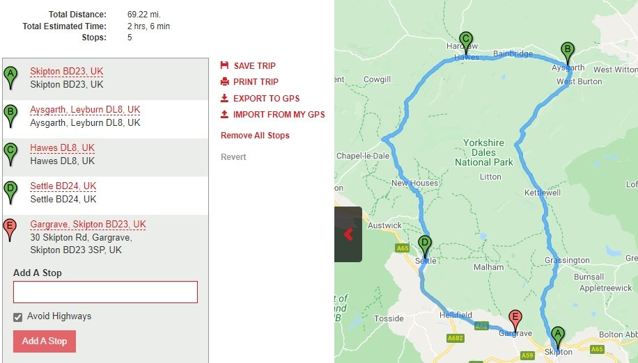
If that is the case - it seems to be based on Google's route planning app. I've just tried a simple route of 5 points.
There is no choice over the type of points created. It just allows you to 'Add a Stop'.
Simple 5 point route in the Honda App - click the image to see it in more detail.

- Honda Route Plan App.jpg (72.29 KiB) Viewed 2180 times
The exported GPX file looks like this.
<rte><name>Gargrave, Skipton BD23, UK</name>
<rtept lat="53.9628495" lon="-2.0162787"><name>Skipton BD23, UK</name></rtept>
<rtept lat="54.2915895" lon="-1.9967434"><name>Aysgarth, Leyburn DL8, UK</name></rtept>
<rtept lat="54.3038282" lon="-2.1968695"><name>Hawes DL8, UK</name></rtept>
<rtept lat="54.06824599999999" lon="-2.277655"><name>Settle BD24, UK</name></rtept>
<rtept lat="53.984331" lon="-2.101438"><name>Gargrave, Skipton BD23, UK</name></rtept>
</rte>
Although the map shows a route drawn on the screen, the gpx file that it creates contains only the route points. When the Zumo XT receives it, it will either calculate its own route between those points, or it will join the points with straight lines. There is nothing wrong with this - the XT will often need to recalculate the route as you ride depending on your settings - but what you get may look nothing like the route that was drawn on the Honda App. In the case where the XT draws straight lines, you would need to force the XT to calculate a route by changing one of the routing preferences or changing the vehicle and then changing it back to Motorcycle.
The XT will interpret each of the route points as Via Points which will insist that you visit them - (unless you elect to Skip a Point).
There is a way to change a Via Point to a Shaping Point on the XT - but both the XT and the 595 have an issue in that they often move the route point to a different location when the Via is changed to a shaping point. This issue has been reported to Garmin and acknowledged.
None of the route points are saved as 'Waypoints' or 'Favourites' or 'Saved' locations.
If a route containing more than 30 Via Points is transferred to the XT, it will split the route into two or more routes, each containing 29 Via Points.
I have observed that some points placed on Google maps have appeared to be slightly differently placed on Garmin's maps. This can cause issues if the point is a Via Point (which it will be), and you fail to visit it (which you will if it is in a field rather than on the road).
None of these issues are such a big deal - they only become a big deal if you are not aware of them and you then try to find work-arounds for a problem that has nothing to do with the XT, but with a planning app which does not talk the Garmin language.
But for many people this is good enough, and they are familiar with the Google interface. And really, that is all that matters. If it works for you, then use it. It doesn't work for me though !
I use Basecamp. Not because I like it, but because it works with the Zumo.
Re: planning with honda trip planner?
Posted: Tue Nov 30, 2021 2:29 pm
by Fxwheels
If it creates a GPX file, you can use it in the XT. I even used a Harley-Davidson planning software to navigate. All 3rd party software will make a similar basic GPX files. But... if you have less then 29 points, Zumo will make them as Via points as FJ said, and will announce them every time. And no, don't change then to Shaping points on the unit itself. Bit if you'll have more than 29, then Zumo will convert them during the upload to a Shaping points and won't annoy you with announcing or insisting on visiting them. I use Furkot and the latest option they have is to load Garmin specific files so it's loaded only using shaping points no matter the number, but the file is huge (300k instead of 10k).
The short answer to your question is yes.
Re: planning with honda trip planner?
Posted: Tue Nov 30, 2021 5:47 pm
by jfheath
Fxwheels wrote: ↑Tue Nov 30, 2021 2:29 pm
But if you'll have more than 29, then Zumo will convert them during the upload to a Shaping points and won't annoy you with announcing or insisting on visiting them.
Mine doesn't do that.
You had me wondering if that behaviour had changed since I tested it last. It hasn't changed. The Via Points in the original do not get converted into Shaping Points. To test it again, and to make sure that it isn't a feature that has changed in recent software updates, I have just loaded in a route with 66 Via Points - including a start and a finish point.
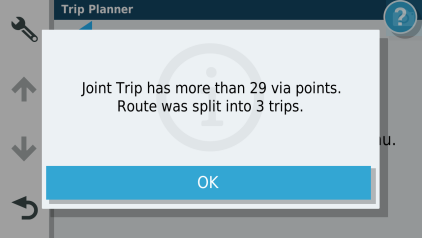
It said that the route had more than 29 Via Points and had been split into 3 trips.
The trip was given the same name as the original with the single digits 1, 2 and 3 added.
Part 1 had 31 Via Points including a start and an end (The end was the 31st Via Point of the original route)
Part 2 had 31 Via Points including a start and an end (The start was the 31st Via Point, the end was the 61st Via Point of the original)
Part 3 had 6 Via Points including a start and an end. (The start was the 61st Via Point, the end was the 66th Via Point of the original)
Total - 68 Via points - because two of the original points were duplicated for the end of one part and the beginning of the next.
None of these via Points was converted to a shaping point.
As a double check, I made some of the original points into shaping points. This time it converted the trip into two parts. The results confirmed that the shaping points do not contribute to the count of 29 Via points, a start and an end point.
If you have a trip with just a start, an end and everything else is shaping points, there are no such issues. You cannot have data displayed - eg distance or ETA to your next stop - only distance and ETA to the end. You have no options available to select where to start the route from when you first load up the route - but the XT's closest entry point gets over that little issue. and shaping points are much more forgiving when navigating. You can ignore them and although it will try to take you back to the missed point, the instant that you find your way back to the plotted magenta line, it will continue to navigate you in the right direction.
If Furkot only produces Shaping Points - that would be a much better option in my opinion than the Honda version which - only seems to produce Via Points. I still maintain that Basecamp is the best tool for the job !
Re: planning with honda trip planner?
Posted: Tue Nov 30, 2021 6:36 pm
by Fxwheels
So when the nav started to import your route, it didn't prompt you if you want to split it into 2 or convert all via points into shaping points?
I wanted to insert a screen print but can't do (or don't know how) from a phone.
If you have all shaping points besides Start and End, you always can go back and convert the needed Shaping point(s) into a Via points.
I know it's an additional input, but learning the BC takes more effort. Sure, ones you master it, it's easy, but if you feel comfortable in what you do, than choose what's works for you.
Yes, Furkot can produce all shaping points and also Via points where you put them along the route. But file will be bigger. It's a newer Garmin specific file.
Re: planning with honda trip planner?
Posted: Tue Nov 30, 2021 8:38 pm
by jfheath
Fxwheels wrote: ↑Tue Nov 30, 2021 6:36 pm
So when the nav started to import your route, it didn't prompt you if you want to split it into 2 or convert all via points into shaping points?
No. I created a 66 point route by joining together all of the days of my last Scotland trip in Basecamp, and then changing all of the route points to Vias. I saved it as Joint Trip. A number of trips joined together rather than smoking anything suspicious. Transferred it from Basecamp and then imported it on the XT.
No prompt, it starts loading it in, gets to 70%, 80%, 90% and then tells you that it has split it into x trips.

- 17786.png (23.32 KiB) Viewed 2148 times
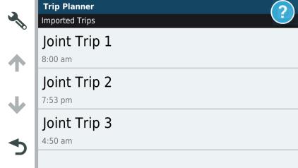
When I displayed the trips it showed these 3 entries.

- 18651.png (20.93 KiB) Viewed 2148 times
The odd times are as a result of the trip being split on points that were originally planned for different days. The times being calculated fromt he satrt of each day. Clearly it has retained that information in the waypoints that I used to create the original trips.
Fxwheels wrote: ↑Tue Nov 30, 2021 6:36 pm
If you have all shaping points besides Start and End, you always can go back and convert the needed Shaping point(s) into a Via points.
Yes - and the Zumo will convert this way without changing the position. It is changing Via to Shaping that presents the problem.
Fxwheels wrote: ↑Tue Nov 30, 2021 6:36 pm
I know it's an additional input, but learning the BC takes more effort. Sure, ones you master it, it's easy, but if you feel comfortable in what you do, than choose what's works for you.
And that is the most important thing. Anyway that works will do.
Fxwheels wrote: ↑Tue Nov 30, 2021 6:36 pm
Yes, Furkot can produce all shaping points and also Via points where you put them along the route. But file will be bigger. It's a newer Garmin specific file.
Yes - that makes it much more useful if it can do both. The size of the file is of very little consequence to the Zumo, it has plenty of space and the extra is probably the additional routing information, which the Zumo will have to calculate and store anyway.
Re: planning with honda trip planner?
Posted: Tue Nov 30, 2021 11:47 pm
by Fxwheels
jfheath wrote: ↑Tue Nov 30, 2021 8:38 pm
No. I created a 66 point route by joining together all of the days of my last Scotland trip in Basecamp, and then changing all of the route points to Vias. I saved it as Joint Trip. A number of trips joined together rather than wamoking anything suspicious. Transferred it from BAsecamp and then imported it on the XT.
No prompt, it starts loading it in, gets to 70%, 80%, 90% and then tells you that it has split it into x trips.
Oh, wow. So the XT does not have that capability of 396... Go figure.

I wish that a 396 would have the XT's "nearest route" option to bring you on route from any location instead of being "creative". BTW, I already mentioned it before, the older Nuvi 1490 had this option. Have no idea why it wasn't carried over.
Well, it is what it is

.
Just out of curiosity, what is the size of a gpx file coming from BC?
Re: planning with honda trip planner?
Posted: Thu Dec 16, 2021 12:05 am
by Fxwheels
jfheath wrote: ↑Tue Nov 30, 2021 8:38 pm
Fxwheels wrote: ↑Tue Nov 30, 2021 6:36 pm
So when the nav started to import your route, it didn't prompt you if you want to split it into 2 or convert all via points into shaping points?
No. I created a 66 point route by joining together all of the days of my last Scotland trip in Basecamp, and then changing all of the route points to Vias. I saved it as Joint Trip. A number of trips joined together rather than smoking anything suspicious. Transferred it from Basecamp and then imported it on the XT.
No prompt, it starts loading it in, gets to 70%, 80%, 90% and then tells you that it has split it into x trips.
17786.png
When I displayed the trips it showed these 3 entries.
18651.png
The odd times are as a result of the trip being split on points that were originally planned for different days. The times being calculated fromt he satrt of each day. Clearly it has retained that information in the waypoints that I used to create the original trips.
Fxwheels wrote: ↑Tue Nov 30, 2021 6:36 pm
If you have all shaping points besides Start and End, you always can go back and convert the needed Shaping point(s) into a Via points.
Yes - and the Zumo will convert this way without changing the position. It is changing Via to Shaping that presents the problem.
Fxwheels wrote: ↑Tue Nov 30, 2021 6:36 pm
I know it's an additional input, but learning the BC takes more effort. Sure, ones you master it, it's easy, but if you feel comfortable in what you do, than choose what's works for you.
And that is the most important thing. Anyway that works will do.
Fxwheels wrote: ↑Tue Nov 30, 2021 6:36 pm
Yes, Furkot can produce all shaping points and also Via points where you put them along the route. But file will be bigger. It's a newer Garmin specific file.
Yes - that makes it much more useful if it can do both. The size of the file is of very little consequence to the Zumo, it has plenty of space and the extra is probably the additional routing information, which the Zumo will have to calculate and store anyway.
My friend has BMW Nav VI and he gets exactly the same message and split into 2 or 3 routes if he's loading a route of more than 29 points.
In a way I like that 396 asks me if I want to split or convert all vias and keep one route. I can convert one or two back to a via if I need.
Edit.
The above is true for loading a regular .gpx files. However if loading Garmin special gpx files, the unit is loading one route and put month/day on the left of route name.
