Page 1 of 1
Google Satellite View
Posted: Wed Mar 15, 2023 9:50 pm
by Les
I rarely (if ever) use Basecamp, much preferring Mapsource.. but occasionally I 'play' with Basecamp... how does one get to view satellite imagery in Basecamp?
In Mapsource I just right click anywhere on the map and get a menu with this option.
Re: Google Satellite View
Posted: Wed Mar 15, 2023 10:35 pm
by Iris
You have to export the file and select a .kml file type.
When google earth is open, you can just drag and drop the .kml file to the earth.
Re: Google Satellite View
Posted: Thu Mar 16, 2023 7:16 am
by sussamb
Les wrote: Wed Mar 15, 2023 9:50 pm
I rarely (if ever) use Basecamp, much preferring Mapsource.. but occasionally I 'play' with Basecamp... how does one get to view satellite imagery in Basecamp?
In Mapsource I just right click anywhere on the map and get a menu with this option.
Does that then take you to satellite view? BaseCamp used to but Google did something that broke that link so I'm surprised to hear it still works from MapSource
Re: Google Satellite View
Posted: Thu Mar 16, 2023 10:23 am
by Les
sussamb wrote: Thu Mar 16, 2023 7:16 am
I'm surprised to hear it still works from MapSource
The 'View' (in Google Earth) stopped working in Mapsource long ago.. however, just right clicking on the maps (in Mapsource) gives the option to view in Google Satellite Imagery.
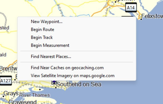
- satellite.jpg (49.32 KiB) Viewed 9558 times
Re: Google Satellite View
Posted: Wed Mar 29, 2023 8:45 am
by Exrm193
As far as I know, Google withdrew the licence, so not possible. Shame, it was a great feature.
Re: Google Satellite View
Posted: Wed Mar 29, 2023 9:50 am
by Les
Exrm193 wrote: Wed Mar 29, 2023 8:45 am
As far as I know, Google withdrew the licence, so not possible. Shame, it was a great feature.
See the post above, it still works with Mapsource.
Re: Google Satellite View
Posted: Wed Mar 29, 2023 12:32 pm
by Peobody
Early in my Basecamp days I found a value in having Google Maps running as well. I often used Google Maps to determine the roads I wanted to ride and then created the route in Basecamp. An integral part of the process is using the street view feature in Google Maps. It is astounding how much street view footage there is for streets in the U.S. Is it the same for the U.K. and Europe?
Re: Google Satellite View
Posted: Wed Mar 29, 2023 2:27 pm
by colirv
Largely yes, except for Germany and Austria.
Re: Google Satellite View
Posted: Thu Mar 30, 2023 12:10 am
by lkraus
Peobody wrote: Wed Mar 29, 2023 12:32 pm
Early in my Basecamp days I found a value in having Google Maps running as well. I often used Google Maps to determine the roads I wanted to ride and then created the route in Basecamp. An integral part of the process is using the street view feature in Google Maps. It is astounding how much street view footage there is for streets in the U.S. Is it the same for the U.K. and Europe?
There is a quite a lot of StreetView coverage all around the globe. I'm a big fan of reading ebooks on my phone. I like being able to tap a city name or an address in a book and then letting Google actually
show me what the author is describing. Even a satellite view of an area can make a story more interesting and understandable.
You can get a rough idea of the areas available in Google Maps by zooming way out, so an entire country or even continent is in view, then click on the the yellow man in the bottom corner of the map. All the blue areas will have StreetViews available.
Re: Google Satellite View
Posted: Thu Mar 30, 2023 12:30 am
by lkraus
Exrm193 wrote: Wed Mar 29, 2023 8:45 am
As far as I know, Google withdrew the licence, so not possible. Shame, it was a great feature.
Google did not withdraw the license, they just raised the price to an unaffordable level. Google charges software developers a fee, based on usage, for access to the Maps API and data. Initially, this was a very tiny amount, so small that developers could absorb it without noticing. Then, a few years ago, Google upped the fees by several thousand per cent, and access became a substantial expense. This is when Garmin dropped the Google features from Basecamp. Furkot also dropped Google as a map source and switched to OpenStreetMaps at about the same time.
There were some prior issues with Basecamp and Google Earth when various "updates" to both programs caused the interaction to fail, but cost is what killed it for good.