Page 1 of 1
Does my Zumo XT have to be plugged in to plan routes?
Posted: Thu Jun 27, 2024 9:49 am
by ic0n
Only recently got a Zumo XT and still learning how it all works. One thing that seems a bit opaque is working with maps. It wasn't obvious to me which map I should be using in the UK for maximum resolution. Eventually I worked out that the XT has to be plugged in to get access to the right map (TopoActive PS Europe West seems to be the answer, unless there's a better option?). This is a bit of a nuisance. Is there a way of accessing these maps without the XT?
Re: Does my Zumo XT have to be plugged in to plan routes?
Posted: Thu Jun 27, 2024 11:17 am
by Oop North John
Are you using Topo maps because you're riding off "normal" roads? City Navigator maps for "normal" roads can be downloaded to the PC and then used by Basecamp, which makes things quicker. But, you need to make sure that the XT's and PC's maps are the same version, otherwise you'll get a warning if you download a route from Basecamp and then open it up in the XT.
Basecamp routes sent to the XT, with a via / way / shaping point, have a bug that has a work around. Looked for RUT - Repeated u-turns to see that whole level of pain it can cause.
Re: Does my Zumo XT have to be plugged in to plan routes?
Posted: Thu Jun 27, 2024 12:26 pm
by ic0n
Are you using Topo maps because you're riding off "normal" roads?
No, it just happened to be the only one listed under the 'Maps' menu one that had the little roads on! Without the XT connected there's only 'Global Map'. With the XT connected under the 'Maps' menu it lists:
CN Europe NTU 2025.10 Foursquare
Europe DEM
Global Map
TopoActive PS Europe Central/East/West
However under the zumo XT device in the left hand pane it adds '
City Navigator Europe NTU 2025.1' - listed twice. Once selected they cover different bits of the world, but it's not evident from the name (as they're identical). My XT was a refurbished model, not new - are my maps different to other XTs?
City Navigator maps for "normal" roads can be downloaded to the PC and then used by Basecamp, which makes things quicker. But, you need to make sure that the XT's and PC's maps are the same version, otherwise you'll get a warning if you download a route from Basecamp and then open it up in the XT.
How do I download the City Navigator maps to the PC? What's the implication of using the TopoActive maps instead of City Navigator? I feel like 'map management' is an under-documented field!
Basecamp routes sent to the XT, with a via / way / shaping point, have a bug that has a work around. Looked for RUT - Repeated u-turns to see that whole level of pain it can cause.
I look forward to all that.
Re: Does my Zumo XT have to be plugged in to plan routes?
Posted: Thu Jun 27, 2024 12:50 pm
by sussamb
Use Express and under Map Options choose Install to computer
Re: Does my Zumo XT have to be plugged in to plan routes?
Posted: Thu Jun 27, 2024 2:14 pm
by ic0n
sussamb wrote: ↑Thu Jun 27, 2024 12:50 pm
Use Express and under Map Options choose Install to computer
Done and done, thanks. Is there some resource that goes into the use of maps in detail? Like, how does the XT decide which map it's going to use? It seems to have multiple maps with coverage of the same area, but which is it using?
Re: Does my Zumo XT have to be plugged in to plan routes?
Posted: Thu Jun 27, 2024 2:26 pm
by lkraus
ic0n wrote: ↑Thu Jun 27, 2024 12:26 pm
No, it just happened to be the only one listed under the 'Maps' menu one that had the little roads on!
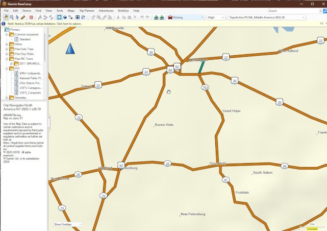
That's interesting as my TopoActive map only shows
major highways in Basecamp, which will not display the "topo" content of the map.

- topo.jpg (59.29 KiB) Viewed 5295 times
However under the zumo XT device in the left hand pane it adds 'City Navigator Europe NTU 2025.1' - listed twice. Once selected they cover different bits of the world, but it's not evident from the name (as they're identical).
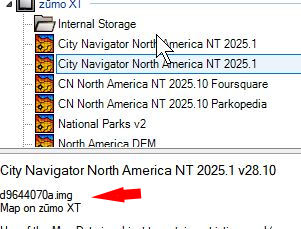
If you select the Zumo CN maps on the left, you'll see the actual file names in the bottom left window. The maps are split up into multiple files because they are too large to fit within the FAT32 file size limit of 4 GB.

- mapname.png (96.01 KiB) Viewed 5295 times
Follow the advice above and use Express with the XT connected to install the City Navigator map on your computer. It will all be in one file and you can use it without the XT being connected. Panning and zooming the Basecamp map window will also be much faster.
Re: Does my Zumo XT have to be plugged in to plan routes?
Posted: Fri Jun 28, 2024 1:33 am
by QuantumQuartz
For maximum resolution in the UK on your Zumo XT, TopoActive Europe West is your go-to map. To access these maps without the device plugged in, you'll typically need to use Garmin's online portal or BaseCamp software on your computer.
Re: Does my Zumo XT have to be plugged in to plan routes?
Posted: Fri Jun 28, 2024 4:30 pm
by ic0n
QuantumQuartz wrote: ↑Fri Jun 28, 2024 1:33 am
For maximum resolution in the UK on your Zumo XT, TopoActive Europe West is your go-to map. To access these maps without the device plugged in, you'll typically need to use Garmin's online portal or BaseCamp software on your computer.
So if I plan the route using TopoActive Europe West in Basecamp and transfer it to the XT, it 'knows' to use this map for navigating?
Re: Does my Zumo XT have to be plugged in to plan routes?
Posted: Sat Jun 29, 2024 5:01 am
by sussamb
No, it'll use whichever map you have selected. Bear in mind having 2 routeable maps covering the same area will cause issues.