Page 1 of 2

XT routing madness

Posted: Sun Aug 11, 2024 10:12 am
by MrLongbeard
Hi all.

Any idea why my XT might be trying to route me down every road in existence when trying to do a simple nav by postcode search?

ImagePXL_20240811_100202656 by MrLongbeard, on Flickr

ImagePXL_20240811_100418854 by MrLongbeard, on Flickr

Re: XT routing madness

Posted: Sun Aug 11, 2024 3:42 pm
by MrLongbeard
Never mind, three full resets later and it's behaving itself

Re: XT routing madness

Posted: Sun Oct 06, 2024 4:05 pm
by Wallace
I know this is no help for you but my XT ruined my trip this year with the same thing.
My carefully planned youte went to hell in a handbasket as soon as I crossed the Elbe into northern Germany, It didn't fix itself for a week.
Wallace

Re: XT routing madness

Posted: Sun Oct 06, 2024 11:16 pm
by jfheath
I've not experienced that exact behaviour, but for some reason it looks like it has a route and then it is going off road to visit a route point, (straight lines) then going back.

Some questions.

What program was used to create the route ?
Do you have two maps selected which both cover the same area - eg OSM maps as well as the Supplied maps. (You can have them both installed, but you cant have them both ticked)
Did you try recalculating the route - eg change vehicle to car and then back to bike.
Do you have any avoidances set ?
Are all of those lines heading for somewhere off the East coast of Africa ? 0.000 N, 0.000W

I'm clutching at straws, but they are not stupid questions. Unless they're wrong.

Re: XT routing madness

Posted: Sun Oct 06, 2024 11:44 pm
by Peobody
Awhile ago I posted about a re-route due to a road closure. The resulting route was what appeared to be a bunch of direct routes to route points that were not part of the original Basecamp-created route. It was not made up of parallel lines or ones that radiated from a single point, they just zig-zagged and crisscrossed through farm and wood land. I was able to manually route myself around the closure and then restart the route. All was well after that. I will add the screenshot image once I find it.

Found it. The black line is the track line of the original route.
CnP_06102024_194759.png
CnP_06102024_194759.png (898.91 KiB) Viewed 2137 times

Re: XT routing madness

Posted: Mon Oct 07, 2024 5:08 am
by jfheath
I wonder if the road closure has something to do with this ?

It looks as though it has a perfectly good alternative route plotted, (if you ignore the straight lines) - given that it cannot go along the route of the black track. But then it has those shaping points to visit.

If you plot shaping points in a field, rather than on a road, then the Zumos get as close as they can to that point and then and bee-line to that point, then double back along the same straight line to where it left the route. If there is another point it does the same thing.

If there are two points close to each other, both on non-navigable roads, it cannot visit one, then the other. It has to visit one, turn back to the navigable part of its route and then straight line to the other.

As far as the XT is concerned the black line is not navigable - there is no road there (there is, but it is closed) - so it is the same as being told to reach a shaping point in the middle of a field.

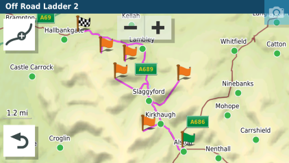
I've seen this in the early days of owning an XT. I was trying its reported abilty to navigate along tracks and trails - so plotted a series of shaping points on a bridleway - open to horses and bicycles, but not to traffic. But the map didn't know about that.

Like this:
12098.png
12098.png (133.53 KiB) Viewed 2077 times

and this:

9261.png
9261.png (96.01 KiB) Viewed 2077 times

Both routes on roads running alongside a hillside. No navigable roads there, so find-your-own-way straight lines it is. A couple of the spurs manage to find a cart track for part of the trek, or someone's drive !

Actually, that recalculated route on your (@Peobody's route - odd as it looks - is perfectly navigable. You follow the instruction and when it turns off in a straight line into a field, you ignore it. You're on the magenta line, its only a shaping point. It wont try to take you back to it. The only issue would be at the right hand end where it finds a side road before it goes across fields, as it is less easy to spot that it is about to take you through the nearest quagmire when it firsts turns you off the main road. But the magenta line going ahead and also taking a side road is a big clue.

I can just about convince myself that this may be a possible reason in @Peobody's case, but there are a lot of assumptions in there. Lots of parallel lines often mean a random point placed thousands of miles away - more than once this has been at 0,0. But my 'explanation' still doesn't fit that case. For it to work, the route would have to be at zero,zero and the lines are heading back to route points on dry land. I can't see how that can happen, short of a corrupted gpx file.

But in Basecamp it is so easy to be dragging and dropping using the insert tool that instead of scrolling the map, your forget that tou still have the previous tool selected and it drops it on the screen. Ever wondered where that 001 Waypoint comes from ? It's usually when you get the world map and you're trying to get it centred around where you live.

Re: XT routing madness

Posted: Mon Oct 07, 2024 2:25 pm
by Peobody
jfheath wrote: Mon Oct 07, 2024 5:08 am I wonder if the road closure has something to do with this ?

It looks as though it has a perfectly good alternative route plotted, (if you ignore the straight lines) - given that it cannot go along the route of the black track. But then it has those shaping points to visit.
The shaping points (blue dots) on the black line are the ones that were in the original route. That is mute though because the closure was right about where the "NC182" badge is. Everything that goes on beyond the shaping point a Johnstown is garbage. It should have routed to that point and then through the remaining route points.

Re: XT routing madness

Posted: Mon Oct 07, 2024 5:03 pm
by jfheath
Yes - I thought that might be the case - BUT - the road closure information is not very precise.

I was once in Derbyshire (middle England) - nice roads, nice hills. I got a warning that the A6 was closed. The A6 is a major road through Derbyshire - but it actually stretches for over 280 miles from just north of London, up to the Scottish border.

I decided to ignore it - there would be road signs surely. I was traveling the A6 north for about 25 miles, and all of the time it kept trying to divert me from it. There wasn't any hint of road works. When we got home, I looked it up. Near to where it was first announced, there was a roundabout. Left headed south, I was heading north. About a mile south of the roundabout, there were some road works - managed by traffic lights. But traffic was flowing. Yet according the satnav the entire section that I was riding was closed

Elsewhere in the Dales, close to where I live, they did some work on the main streets of a few small towns. The sections of road were closed for this work, at the same time - but only from 22:00 to 06:00 The rest of the time the traffic was flowing reasonably freely. Yet according to the info that the satnav was getting, it wasn't at all passable.

So it's not what is actually there - it is what the satnav has been told is there. And it is not to be relied upon.

Maybe it wasn't the road works - but I reckon that your scenario is close enough to the examples I gave for it to be something like that.

The route has recalculated, and for some reason it does not think that the black track road can be navigated. But it has to visit the shaping points.

Re: XT routing madness

Posted: Thu Oct 10, 2024 9:35 am
by colirv
Where does the road closure information come from? I've never seen any on my XT.

Re: XT routing madness

Posted: Thu Oct 10, 2024 11:09 am
by jfheath
colirv wrote: Thu Oct 10, 2024 9:35 am Where does the road closure information come from? I've never seen any on my XT.

You need to pair your phone by BT to the XT
From the Drive app on your phone. Settings->Traffic needs to be enabled


You also need to set up Drive. Sign into your Garmin account. If you don't have one, you need to create one on a web bowser explore.garmin.com

When you set up drive, allow access to what it wants - locations all the time, and notifications. You can configure notifications laters. But do not agree to set up Explore on your XT. Maybe later is the option to choose.


With notifications, the XT will display all sorts of stuff emails, facebook, messages. etc. You can turn these off from the drive app on your phone if it is android. you can turn them off on the XT if you have linked an iphone