Page 1 of 3

Double Route Line on Importing BC GPX route

Posted: Tue Aug 20, 2024 2:12 am
by LQQK_OUT
I have another question regarding a route I created on Basecamp. Can anyone tell me why the following route doesn't display correctly on a Zumo XT2? The route displays correctly on a Zumo 595 and in Basecamp. I actually have a couple of routes that don't seem to display correctly on the XT2, that were created with Basecamp. Part of the route appears as a straight line along with a curvy line of the actual route. My guess is this is a bug.


Screen Shot of XT2 route
XT2Route.jpg (265.1 KiB) Viewed 1248 times

Double Route Line on Importing BC GPX route

Posted: Tue Aug 20, 2024 5:48 am
by jfheath
Interesting little problem. Thanks for including the GPX file.

Ok - so I get to use my USA maps for the first time in earnest.

My XT2 displayed exacly the same results as yours. I thought at first it was because the end point was plotted off route - but that isn't something that I had seen before. I changed the next to last point to a Via - and that got rid of it. But then when I imported it again the probelme reappeared.

So I looked closer at each route point in turn in Basecamp. All was OK.
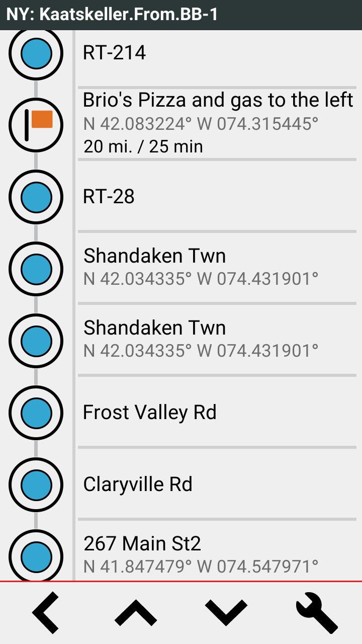
So I looked at the list in the XT 2.

Look what I found:
Look-Out.png
Look-Out.png (143.97 KiB) Viewed 1239 times


Compared to the Basecamp list :


LookOut 2.jpg
LookOut 2.jpg (24.74 KiB) Viewed 1239 times


Shandaken Twn is the name that XT2 has allocated to Catskill Park8112. The coordinates are the same. But it has put it into the route twice.
You wouldn't notice this just by looking - the route list shows a number of locations names twice - but they are roads and the points are in different positions.

I tried deleting one of them - but that didn't work on the XT2.
So I created a track of the route and used it as a reference to see what happens if I deleted the Catskill Park shaping point completely. It stayed the same. And when I sent that to the Zumo XT2 - it looked perfect.

Don't ask. I haven't got a clue. I don't know if that straight line is a branch or if it is the same route coming back. I've yet to try to simulate the route from Brios Pizza and Gas to see what it looks like to navigate - and which route it takes.


Anyway - see if you get the same results by deleting that shaping point.
I'll continue to ponder on it - there has to be something about that point.....
... or the number of points
... or the loop back on itself (it is the first point after the loop).
I didn't try to make it a Via . Perhaps it needs on to separate the segments - although Brios Pizza and Gas is a Via point. That should be enough.

I don't know. I've just looked through that section of the GPX file - there's nothing wrong that I can see. :(

[afterthought] I have just forced the XT2 to recalculate the route. (I did this by going into Navigation and setting avoid ferries), then reloading the route. IT informs that avoidances have changed, so I want to recaculate. Yes please. The double entry for Shandaken Twn is still there, but the route plots properly.

It reminds me of that error in Basecamp when you move a different point to the start or the end. The straight line map that is displayed develops an extra limb - with three straight lines coming out of one of the points !

Edit - just running a simulation from the Brios. The first shaping point on the map is quite close to Shandaken town. THe second point where the route splits is some way from Shandaken town.

Double Route Line on Importing BC GPX route

Posted: Tue Aug 20, 2024 11:27 am
by jfheath
Following on from my answer above, this is what the navigation screen looks like when the Stanav is approaching the Shaping point with the extra route tagged onto it. The straight line rought is the one to the right. Undser simualtion, the satnav doesn't even recognise it as a junction (look at the distance to the next turn in the top left), and it carries on across that junction without pause - as if it isn't there.

Weird Straight Extra Line.png
Weird Straight Extra Line.png (91.5 KiB) Viewed 1218 times

Double Route Line on Importing BC GPX route

Posted: Tue Aug 20, 2024 11:42 am
by LQQK_OUT
jfheath wrote: Tue Aug 20, 2024 5:48 am Interesting little problem. Thanks for including the GPX file.

Ok - so I get to use my USA maps for the first time in earnest.

My XT2 displayed exacly the same results as yours. I thought at first it was because the end point was plotted off route - but that isn't something that I had seen before. I changed the next to last point to a Via - and that got rid of it. But then when I imported it again the probelme reappeared.

So I looked closer at each route point in turn in Basecamp. All was OK.
So I looked at the list in the XT 2.

Awesome analysis! Thank you.
Now I know what to look for and can try and modify the routes in Basecamp. I may also purchase MRA and try that. I'll call Garmin tech support and report this issue. As I mentioned in my post above, I have a few routes that do this and these routes all worked properly on my Zumo 595.
Thank you again for spending the time and looking into this.

Double Route Line on Importing BC GPX route

Posted: Tue Aug 20, 2024 11:43 am
by jfheath
Simulate Routes at Extra Speed

The XT2 has a new feature in the hidden system menu. You can modify the speed of the simulation so that the motorcycle travels faster. From normal speed up to 3x speed in 0.5x increments.

When I tested it, I had to set the speed AFTER I had started the simulation. But that may or may not be necessary every time.

To access this feature. Long press the circular speedo after tapping on the map's speed button.
Select Configurations & Settings -> NAV Sim Multiplier
Each press increases the multiplication factor - in a cycle.
Back out and the simulated navigation will continue running. Note the speedo.

Some Screen shots:

Speed Up Simulation.png
Speed Up Simulation.png (168.98 KiB) Viewed 1211 times

I cannot find anything that might offer the same facility on the XT1

Double Route Line on Importing BC GPX route

Posted: Tue Aug 20, 2024 12:50 pm
by jfheath
LQQK_OUT wrote: Tue Aug 20, 2024 11:42 am Awesome analysis! Thank you.
Now I know what to look for and can try and modify the routes in Basecamp. I may also purchase MRA and try that. I'll call Garmin tech support and report this issue. As I mentioned in my post above, I have a few routes that do this and these routes all worked properly on my Zumo 595.
Thank you again for spending the time and looking into this.
I couldn't see anything wrong with the Basecamp route. It had Catskill Park listed just once.
It was the XT2 that created Shankdaken twice. - And it was quite a way from Shankdaken.
I didn't try deleting ShankDaken from the XT2 list - but that would have recalcualated the route and recalculating the route removed the problem (but not the duplicated point) anyway.
I think that they will put it down to a mapping error. But yes tell Garmin. I find it best to get onto the phone and talk to someone to explain. They will suggest the basic stuff, and you tell them it has nothing to do with anything that you have done wrong. It has nothing to do with Basecamp. If it has something to do with GPX files, that's OK - their XT2 allows the import of GPX files, and it is processing this particualr route incorrectly.

If you want my full size screen shots, let me know.

Double Route Line on Importing BC GPX route

Posted: Tue Aug 20, 2024 3:32 pm
by LQQK_OUT
I called Garmin support and spent quite a bit of time speaking with them. They did not have a 595 to test with, but did have a Zumo XT. She loaded the route into the XT and claimed it did work properly on that platform.
Next, she thought there might be an issue with using Basecamp to transfer the route to the XT2, since it's not supported. She copied the route directy to the sd card and loaded it into the XT2. I don't think that initially worked, but she changed an avoidance to cause a recalculation and claimed after the recalculation, that it now was working. She made some notes in her computer application and said to call back if I still have any issues,

I tried that myself and I don't think the recalculated route is the same/correct. I need to do some more testing later since I don't have the time right now. I still think this is some sort of bug. Why would I need to recalculate the route after I loaded it via the sd card? That doesn't make any sense.

Can you possibly try loading this route on the Zumo XT to confirm it works on that platform?

Re: Poll : Curious about the Zumo XT2 ? Read on....

Posted: Tue Aug 20, 2024 6:04 pm
by Peobody
LQQK_OUT wrote: Tue Aug 20, 2024 3:32 pm Can you possibly try loading this route on the Zumo XT to confirm it works on that platform?
It looks fine on my XT. One oddity though. Right at the end of the import process there was the flash of a dialog that started with the word "No". I have never noticed that before and am clueless what it actually said.

Nice looking route though. I have ridden in that area numerous when enroute to CT from NC and riding off the interstate. Lodged in Wurtsboro a couple of times. Once, while in search of food, I came across a hot dog food truck parked near the Stewart airport. Man, that was almost three decades ago, during a car trip with my daughter. I think was 6 at the time. Thanks for the memories.
pasted.png
pasted.png (536.58 KiB) Viewed 1176 times

Double Route Line on Importing BC GPX route

Posted: Tue Aug 20, 2024 6:31 pm
by jfheath
Recalculating the route in Basecamp does not change things.

Recalculating the Route on the XT2 does. (But there isn't a recalculate option on the XT2 - you have to change avoidances, and if you do that, then forever after you get alert messages for every other route in the XT2. That cannot be the answer !!

I tried shortening the route - deleting the route points before Brios Pizza and keeping only the following 4 route points.

Shortened weird route.png
Shortened weird route.png (764.83 KiB) Viewed 1169 times

I'm just going to compare the <rtept> commands in the Basecamp file with the ones that have been created in the Zumo XT (from Current.gpx). I have a sneaking suspicion that the route points are getting out of synch when the XT2 processes it. We shall see.


I might move all of these posts to its own new thread (eventually). If I do I'll leave a temporary pointer to it in this thread.

Double Route Line on Importing BC GPX route

Posted: Tue Aug 20, 2024 6:55 pm
by LQQK_OUT
Peobody wrote: Tue Aug 20, 2024 6:04 pm Nice looking route though. I have ridden in that area numerous when enroute to CT from NC and riding off the interstate. Lodged in Wurtsboro a couple of times. Once, while in search of food, I came across a hot dog food truck parked near the Stewart airport. Man, that was almost three decades ago, during a car trip with my daughter. I think was 6 at the time. Thanks for the memories.
This is just half of a great ride through the Catskills. Not sure if you are familiar with Platte Cove Road. The Tour De Trump (bicycle race) raced up that road. The racers didn't think American roads would be so steep and choose the wrong gearing on their bicycles. Many ended up walking up. Motorcycles brought to a crawl by the slow moving peleton fell over and some officials cars overheated.