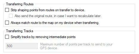
- Edit Options.jpg (17.51 KiB) Viewed 4815 times
This is what I understand happens with these settings. I have tried and used all of them at various times - particularly when writing the document about Basecamp and the 590/595. There may be other reasons and explanation that I am not aware of. Feel free to chip in if you know alternative facts !!
1. Strip Shaping Points.
A route can consist of Via Points (which will alert on arrival) and Shaping Points (which will not alert on arrival)
Do not confuse with Waypoints. Stored Waypoints can be added to a route, but when they are, they become Via Points on the route, or can be changed to non alerting shaping points. A Waypoint is not the term to use when describing the routing points that make up a route.
If this is ticked, all of the shaping points are removed from the route - but the route on the Zumo remains exactly as it was when the shaping points were there. Garmin achieves this by sending a load of invisible route points (I call them ghost points) along with the route. The trouble with this is that if the zumo has to recalculate a route, it does so between the shaping points and via points and all of those ghost points are lost. This is particularly true with the XT - if (say) you use the Skip function - the entire route is recalculated.
2. Also send the original route.
If you ask Basecamp to strip out the shaping points, you may find that you want the route that had the shaping points in place. Ticking both of these boxes will send two routes to the Zumo - one with the shaping points, one without.
Whichever you select - the Via Points (alerting) are always sent to the Zumo.
3. Always Match route to the map.
The Zumo works best if you use Basecamp maps and the maps in Basecamp are identical to the maps on the Zumo. In this case, transferring and importing routes takes just a few seconds. If the Zumo detects that the map used to create a route is different from the one in the Zumo, the Zumo will recalculate the entire route, plotting a course between the Via Points and Shaping Points that the route provides.
It needs to be able to do this if for example an older Basecamp map shows an old road but the Zumo map has the new bypass.
To do this recalculation, it uses the settings in the Zumo (faster, shorter, avoidances etc) and will probably come up with a different route from the one that you saw in Basecamp. But this recalculation takes a lot of time.
Ticking this box ensures that the Zumo always does this recalculation. It therefore always takes a long time to transfer and to import the routes. But it gives you the opportunity to see the route that the Zumo will calculate, rather than it coming up with a surprise when you are on tour. But there are other, faster ways of achieving this.
4 Simplify tracks
A track is not navigable. You can use Basecamp to convert a route into a track, and you can send that to the Zumo and the Zumo can be set to display the track on the screen - in a different colour (say). This is very useful if you have a route which may recalculate when you are riding. If you display the track as well, then you have a view of where the original route was before the Zumo changed it. The Zumo will show both on screen simultaneously.
The Zumo also records a track of where you have been (thousands of dots which include information about time, date, speed, elevation). These are a useful record of where you have been and when, and can be displayed on the BAsecamp maps and be used to create things like elevation and speed profiles. This is completely irrelevant to the Simplify Track function - Except - Sometimes it is useful to recreate a route from an old track. BAsecamp and Zumo can both do thise, but you end up with far too many points. A route may typically contain say 10 key points and it lets the stanva work out where to go in between. A track contains thousands of points. Basecamp and Zumo simply join the dots with a short straight line. Together it looks like smooth curves.
There may be situations where you want to reduce the number of points in a track. So this feature allows this to happen. So if the original track has 5000 points and you set a limit of 500 points, Basecamp will pick every tenth point and join them together with a (longer) straight line.
I use my tracks a lot - and have all of my trips from around 2007. I have never felt the need to cut down the number of points.
I recommend making sure that all of these boxes are unticked - Unless you know that you want that particular feature.