Hi
@hppants
Thanks for your reply - I've trimmed it down so that it focuses just on the issues that you are having.
hppants wrote: Fri Aug 05, 2022 8:04 pm
Thank you for your reply. First, my #1 question is ONLY related to tracks that are CURRENTLY being built and NOT SAVED.
Ah - I misunderstood you comment :
"When viewing the map, occasionally I see roads that are depicted in red - the SAME red color as my unsaved track. :"
Since you said that it was the same colour as your unsaved track, I assumed that you were not referring to the track that you were currently recording.
hppants wrote: Fri Aug 05, 2022 8:04 pm
Second, there is no way that traffic is causing the roads to be red - most of the roads I've seen this on are unpaved and I have the traffic layer turned off, thinking the same thing.
I didn't know this. You said that you occasionally see
roads depicted in red.
If the red line disappears when the topoactive map is turned off, is it perhaps something on the map itself - perhaps a track or path ?
Looking at your map more closely, I can see the red recorded track going falong Gates Chapel Road and there are places where I can see that it goes back again. Errorors int he track are bound to happen - satnavs generally have around a 3m accuract when plotting points. The recorder plots a point at certain time intervals maybe every 1-2 seconds - perhaps a but longer. It joins up the points with straight lines - so you are likely to see your track going off the road that it plotted on the map.
----------------
I experimented with the Recorder a couple of times last week. I normally just use the track logs, which are recorded all of the time, so I have just done a quick analysis. On a 56 mile trip, it recorded roughly 2000 points. Of these, 1081 points were recorded within 1 second of the previous point. 1725 were recorded within 5 seconds of the previous point. The largest gap between one point and the next was 12 seconds. You can load the track into Basecamp, and this will show each of the points that were recorded. See the image below. Note that you can also inspect the track and display graphs of the speed, elevation and link this to where you were on the map. Click for a larger view:
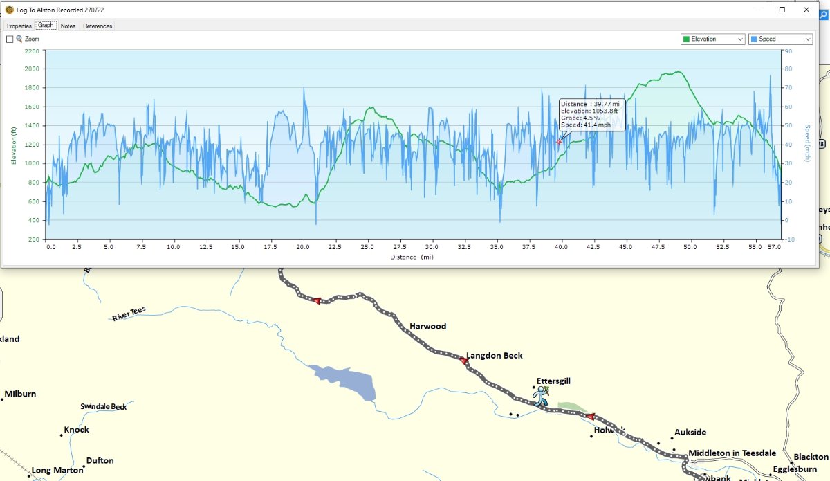
- Track Points.jpg (98.93 KiB) Viewed 1889 times
It is easy to see that the interval isn't fixed. There are many more points recorded where the road bends, and the big gaps appear on the straight sections. Of course, this is where I am travelling, slower, or faster respectively. I don't know how it would behave going at slower speeds off road.
---------------------
The Forest Service Road 241 appears to be a red coloured road that is part of the map itself. I have never looked for a key or legend to understand what colours are used to depect different types of road on the map, but it is normal for maps to use different colours for different types of road. Maybe this is what you are seeing with the Topo map?
I have noticed that tracks being recorded (using the XT Record button) appear on the my screen in an orange/red colour.
Tracks that are being logged as part of the current activity are usually shown in a light blue. These can be turned off by not allowing your travel history to be logged - Settings->Device->Travel History.
Or they can be logged but not shown - which is contolled in the Map Layers : Settings -> Map&Vehicle -> Map Layers.
I think that the cyan coloured track log is the same width as the magenta route. And I think that the track recording track (the red one) is a bit thinner and lies on top of the plotted route. But that is relying on memory, which is never a good thing these days !
-------------------
None of the above are answers, but they might be thing that you can use to pin down the origin of the unknown red line.
Most tracks and routes - the colours, widths and borders are affected by which theme you choose to use.
I find it useful to have tracks plotted slightly wider than routes, so that I can display a track and a route at the same time, with the track underneath peeping out from under the Magenta route. This makes it easy to see whether or not a route has been recalculated - it gives me the choice of following the original (track) or following the recalculated route.
It is easy enough to select a different theme on the Zumos, but the ability to edit a theme isn't built into the XT. However it is easy enough to edit the theme file with a simple text editor, if you are so inclined. If not find someone that has already done it and ask them for a copy of the file to put on your XT. It will then appear in the list of available themes.

