106 RUT - with U-Turns disabled
| Contents | First | Previous | Next |
Closest Point - The 'Turn Back' Loops
I am going to take a close look at each of those 'turn back' loops. They reveal something that is really quite important in understanding how the XT seems to be behaving.
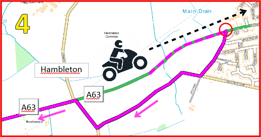
Pic 4 - Hambleton

I have ignored the request to go back to the A1(M), and so far they have all been perfectly reasonable requests - Until I get past Hambleton, faster route is to turn back to the A1(M).
The picture shows me heading in the 'wrong' direction - east along the A63. The XT has found a way to turn me back towards the A1(M), and that juntion is up ahead at the red circle. So it plots the magenta line - including the section that I have shown as dotted - to lead me to the junction and turn me right and then back to rejoin the A63 behind me. The start of its new route is at the red circle but it is navigating me to that point. I am about to ignore its instruction.
As soon as I go past the junction where I should turn right, that red circle marks a very significant point. It is a marker for the start of the section of route that it has calculated to get back to the A1(M) - and that section back to the A1(M) includes the side road loop.
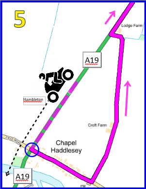
Pic 5 - Chapel Haddlesey

Here is a similar situation. I am now a long way past Hambleton, on the A19 heading SW (ish). Although it is now much faster to go the way that I am travelling, the XT is intent on getting me to go back to the red circle and then back towards the A1(M) where I first deviated from its original route.
Up ahead, it has spotted a left turn which it can use to get me to turn back onto the A19 heading NE. The blue circle marks the start of a new section of the active route which connects the blue circle to the red circle.
Not that I have not said that it is trying to get me to the A1(M). That is because this new section of route is calculated only as far as the red circle. If it was calculating a route to the A1(M), it would stick to the A19 and the A63. But it doesn't do that, as I will explain later.
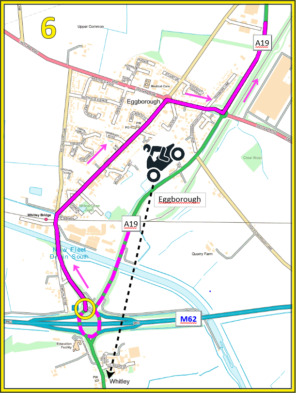
Pic 5 - Eggborough

Similar situation. Still on the A19 heading south(ish), the XT spots a final opportunity to route me back to the start of its last calculated active route - which is at the blue circle. This time it finds a roundabout and a little side road through Eggborough to get me to rejoing the A19 heading north.
Interestingly, it does not seem to be allowed to go all of the way round the roundabout at take the A19 exit. I suspect that it is because rejoining the same road in the opposite direction is classed as a U-Turn.
The XT calculates a new section of route, which starts at the yellow circle and finishes by joing the previous section of currently active route at the blue circle.
OverView Map and Summary

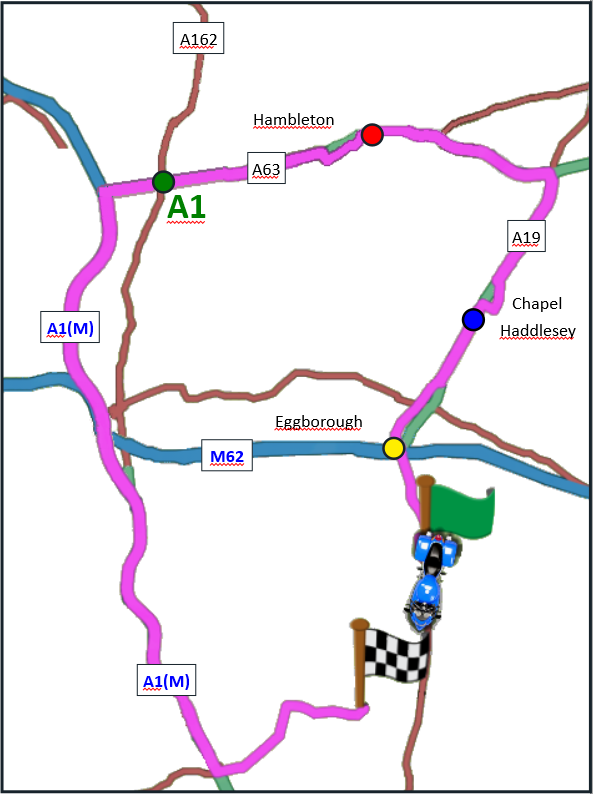
Looking at the entire route from where I deviated - marked as A1 - the 3 detours shown in Pics 4, 5 and 6 are still visible in the route from my current position back to A1. So the active route goes from my current position:
I think that it only calculates to the closest point on the active route. On the maps above in the coloured squares, the plotted route turns me off the main road that I was traveling and routes me back. That point is its new section of route. When I ignore the instruction to turn it is looking ahead to find a way to get me back to the point - and only calculates as far as that point. That means the side road loop becomes part of its new route.
If U-turns are allowed, the XT can spin you round anywhere, and no evidence of how it is working out the route is left - but it still seems to be calculating a route back just to that last 'turn round' command.
There is another point of interest at Eggborough. The M(62) leads directly to the A1(M) and the original active route is just 4.5 miles to the west. But the XT isn't tempted, so it does not seem to making any effort to find a brand new route to the next route point. I suspect that is because the start of its last recalculation - the blue circle - is much closer than the magenta line where it crosses the M62 further to the west .
I have some indications that this behaviour happens at other times - without pressing skip. But that requires further research.
But I cannot make it behave in this way if the route is created on the XT screen, or if the route is tweaked so that it appears in the 'Saved Routes' list.
- Back to yellow circle
- Back to blue circle (incuding the eggborough 'loop back')
- Back to red circle (including the Chappel Haddesley 'loop back')
- Back to A1 (including the Hambletom 'loop back')
I think that it only calculates to the closest point on the active route. On the maps above in the coloured squares, the plotted route turns me off the main road that I was traveling and routes me back. That point is its new section of route. When I ignore the instruction to turn it is looking ahead to find a way to get me back to the point - and only calculates as far as that point. That means the side road loop becomes part of its new route.
If U-turns are allowed, the XT can spin you round anywhere, and no evidence of how it is working out the route is left - but it still seems to be calculating a route back just to that last 'turn round' command.
There is another point of interest at Eggborough. The M(62) leads directly to the A1(M) and the original active route is just 4.5 miles to the west. But the XT isn't tempted, so it does not seem to making any effort to find a brand new route to the next route point. I suspect that is because the start of its last recalculation - the blue circle - is much closer than the magenta line where it crosses the M62 further to the west .
I have some indications that this behaviour happens at other times - without pressing skip. But that requires further research.
But I cannot make it behave in this way if the route is created on the XT screen, or if the route is tweaked so that it appears in the 'Saved Routes' list.
| Contents | First | Previous | Next |
The information on these pages has been acquired from personal experience of using and testing the behaviour of Basecamp and my Zumo XT. I have no links with Garmin, and these pages should not be regarded as instructions. They are presented for interest only. The contents of these pages must not be shared, copied, transmitted, redistributed or re-published in any form without my permission. (C) JHeath 2021.