Interesting Questions
@Peobody
@lkraus has already picked out a lot of mis-understandings. I'll try to fill in the gaps.
There are Waypoints and there are non-Waypoints.
Waypoints have to be created before you use them in a route either by you with the flag tool or by somebody else (eg by Garmin).
A Waypoint will appear in a route as either alerting - Via Point - (which is the default) or as non alerting - Shaping Point.
Waypoints get transferred to the Zumo and are added to the 'Favourites' or 'Saved' store.
Waypoints will appear in Basecamps lower left window pane along with the routes and tracks.
Non-Waypoints are usually created when you use the New Route Tool or the Insert Tool.
Non-Waypoints will appear in the route as either alerting (Via) or non-alerting (Shaping). They have to be one or the other.
When using the route tool or the drag and drop Insert tool - you click the place where you want the route to pass through.
The result will be either a Via Point or a Shaping Point.
This behaviour is difficult to predict - because if you click somewhere near to a known / named location, Basecamp will assume that you meant to click on that point, and jump to it. Even if the place isn't showing on the map. This is why you often get locations on your route which are supermarkets or petrol stations. As a sweeping generalisation, known locations - ie places that Basecamp has already named - are placed in the route as alerting (Via) points. Places without a name are set initially as non-alerting (Shaping) points.
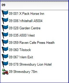
It is difficult to know whether a point was set created initially as a Waypoint. And to a large extent is doesn't matter. The only sure-fire way of knowing in Basecamp is that Waypoints appear in the lower left pane in Basecamp for the currently selected List or List Folder.
In the example below Most points have been create as Waypoint. Only the start, end and a couple of coffee stop options (at 28 miles and 59 miles) are set as Via Points - in this case to flag up as route markers for the Pillion to see progress to known landmarks.

- BC Lower Left Window.jpg (19.92 KiB) Viewed 3400 times
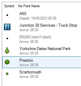
When points are added to the route, they acquire a symbol.

- BC Points.jpg (17.24 KiB) Viewed 3401 times
These seem to be related to the size of a town (green circles), or a particular type of venue. Mostly the named points are set as Vias. The small black dots (typically road numbers) are set as Shaping. I have also seen slightly larger black squares - I can't recall when these crop up. None of these are Waypoints in this route.
Because of the point jumping to a nearby location, it is difficult to predict whether an inserted route point will be a Via or a Shaping when it is first placed.
I like to have mainly shaping points with a few Vias - usually placed on the road I want to be on after a coffee Stop - so I highlight all of them in the route properties dialogue box - except start and end - right click and choose 'Don't alert on Arrival'. That sets them all to Shaping points.
(You cannot change the start and finish to shaping points. They have to be Via Points.)
Then I go through and set each point that I want to be a Via back to alert on Arrival. These have to be done individually - you cannot multiselect items that are not adjacent in the list.
There are a few common errors in posts that you read.
Using the term Waypoint to mean any route point. This is becoming more common since MyRoute App has taken off as a popular mapping program. MRA uses the term Waypoint to mean any point on a route. But this is a Zumo Users Forum - Garmin. And Garmin uses the term Waypoint to mean a previously saved location. Garmin Waypoints have additional properties, like address, phone number which are all picked up by the Zumos and can be used to place a call, for example.
Using the term Waypoint to Mean Via Point. I often see phrases like 'I changed it from a Waypoint to a Shaping Point' - which doesn't make sense. Once a Waypoint, always a waypoint. But you can use it as a Via Point in a route or as a Shaping Point in a route, and how you use it can be altered.
When I got the XT - my use of Favourites / Waypoints changed.
I had got used tot he fact that I could name my route points to be anything that I wanted - so I could use something that I recognised. Particularly in places that I didn't know very well. eg for me, Skipton, Kirkby Lonsdale, Penrith, Alston, Longtown, Moffatt, Dunoon, Inverary, Fort William form a perfectly logical natural progression. But I need to look at a map for names that I have heard of like Chippenham, Warminster, Andover, Marlborough, Oxford, Newbury, Reading. If I was in Newbury, I don't have a clue which town is next travelling west.
So I put day numbers (to make them easier to find on the Zumo, and becasue I may go tot he same place twice on different days), and either mileage or sequence numbers so that I can see which comes next. So 03 123 Longtown, 03 164 Moffatt.
Except the XT has scuppered this little ploy, because one of the first things that it does when trransferring or loading in a route is use the lat/long coordinates to find the nearest place in its database, and substitutes that. So my convenient numbering system has gone. I'm stuck in Newbury having to restart my route, and I havn't got a clue which comes next. I need a map.
Except - not if I use Waypoints. It never renames a Waypoint.
So I've started keeping waypoints on Basecamp. And clearing out my favourites from the Zumo for every trip, and just transferring what I need.


