I wonder if the road closure has something to do with this ?
It looks as though it has a perfectly good alternative route plotted, (if you ignore the straight lines) - given that it cannot go along the route of the black track. But then it has those shaping points to visit.
If you plot shaping points in a field, rather than on a road, then the Zumos get as close as they can to that point and then and bee-line to that point, then double back along the same straight line to where it left the route. If there is another point it does the same thing.
If there are two points close to each other, both on non-navigable roads, it cannot visit one, then the other. It has to visit one, turn back to the navigable part of its route and then straight line to the other.
As far as the XT is concerned the black line is not navigable - there is no road there (there is, but it is closed) - so it is the same as being told to reach a shaping point in the middle of a field.
I've seen this in the early days of owning an XT. I was trying its reported abilty to navigate along tracks and trails - so plotted a series of shaping points on a bridleway - open to horses and bicycles, but not to traffic. But the map didn't know about that.
Like this:
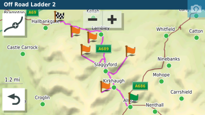
- 12098.png (133.53 KiB) Viewed 4669 times
and this:
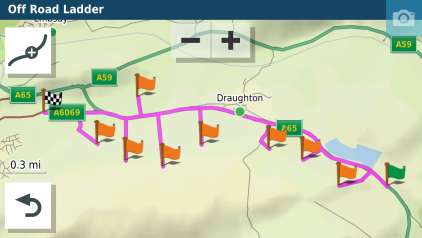
- 9261.png (96.01 KiB) Viewed 4669 times
Both routes on roads running alongside a hillside. No navigable roads there, so find-your-own-way straight lines it is. A couple of the spurs manage to find a cart track for part of the trek, or someone's drive !
Actually, that recalculated route on your (
@Peobody's route - odd as it looks - is perfectly navigable. You follow the instruction and when it turns off in a straight line into a field, you ignore it. You're on the magenta line, its only a shaping point. It wont try to take you back to it. The only issue would be at the right hand end where it finds a side road before it goes across fields, as it is less easy to spot that it is about to take you through the nearest quagmire when it firsts turns you off the main road. But the magenta line going ahead and also taking a side road is a big clue.
I can just about convince myself that this may be a possible reason in
@Peobody's case, but there are a lot of assumptions in there. Lots of parallel lines often mean a random point placed thousands of miles away - more than once this has been at 0,0. But my 'explanation' still doesn't fit that case. For it to work, the route would have to be at zero,zero and the lines are heading back to route points on dry land. I can't see how that can happen, short of a corrupted gpx file.
But in Basecamp it is so easy to be dragging and dropping using the insert tool that instead of scrolling the map, your forget that tou still have the previous tool selected and it drops it on the screen. Ever wondered where that 001 Waypoint comes from ? It's usually when you get the world map and you're trying to get it centred around where you live.
 PXL_20240811_100202656 by MrLongbeard, on Flickr
 PXL_20240811_100418854 by MrLongbeard, on Flickr